Filter: Categories of Wisconsin Historical Images
Filter: FORMAT_TYPE of prints, photomechanical
Filter: Subject of transportation
Filter: Subject of administrative agencies
Filter: Categories of Wisconsin Historical Images
Filter: FORMAT_TYPE of prints, photomechanical
Filter: Subject of transportation
Filter: Subject of administrative agencies
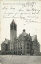
| Date: | 1909 |
|---|---|
| Description: | Building with tower from street level. Two flags fly are on top of the building. Caption reads: "Government Building and Post Office, Milwaukee." |
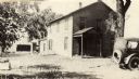
| Date: | 1936 |
|---|---|
| Description: | A view of the Indian Agency House, built in 1832. |

| Date: | 1883 |
|---|---|
| Description: | A hand-colored map of Wisconsin showing the nine congressional districts, it also shows the counties, cities, railroads, rivers, and lakes in the state. |

| Date: | 1845 |
|---|---|
| Description: | Wisconsin was considered part of Michigan Territory until 1836, a year before Michigan entered statehood. Drawn three years before Wisconsin entered stateh... |

| Date: | 1889 |
|---|---|
| Description: | Shows city limits, railroads, mills, schools, cemeteries, dams, parks, lumber yards, log canals, log reservoir, Chippewa River, Eau Claire River, and Half ... |

| Date: | 1939 |
|---|---|
| Description: | This is a zoning map of Wauwatosa with a key of districts including agricultural, resident, business, commercial, and industrial. The map features labeled ... |

| Date: | |
|---|---|
| Description: | Wisconsin Division of Tourism poster. View toward a woman sitting on a log at the shoreline of a lake or river with a bicycle laying on its side in the for... |
If you didn't find the material you searched for, our Library Reference Staff can help.
Call our reference desk at 608-264-6535 or email us at: