 Filter: Categories of Wisconsin Historical Images
Filter: FORMAT_TYPE of prints, photomechanical
Filter: Subject of transportation
Filter: Subject of apostle islands
Filter: Categories of Wisconsin Historical Images
Filter: FORMAT_TYPE of prints, photomechanical
Filter: Subject of transportation
Filter: Subject of apostle islands

| Date: | 1886 |
|---|---|
| Description: | Bird's-eye view of Ashland, on the shores of Lake Superior, with insets of The Apostle Islands Chequamagon Bay & Ashland, and Distances from Ashland. |

| Date: | 1886 |
|---|---|
| Description: | Bird's-eye map of Washburn on Lake Superior. There is an inset of Washburn, Chequamagon and the Apostle Islands. |

| Date: | 1905 |
|---|---|
| Description: | Camp Stella looking south toward the Bayfield County shoreline from an Apostle Island. |

| Date: | 1878 |
|---|---|
| Description: | A color map detailing Ashland and Bayfield counties, including Lake Superior and the Apostle Islands. |
| Date: | |
|---|---|
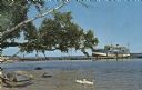
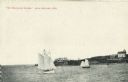
| Description: | Postcard of the excursion boat the "Chippewa" docked in Bayfield, before taking passengers to the Apostle Islands. Two ducks can be seen swimming in the fo... |
| Date: | |
|---|---|
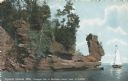
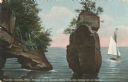
| Description: | Postcard of the "Indian Head," or profile, a geological rock formation on the shorelinr. Caption reads: "Apostle Islands, Wis. Presque Isle or Stockton, In... |
| Date: | |
|---|---|
| Description: | Colorized postcard of the Profile Rock geological formation among the Apostle Islands on Lake Superior. A sailboat is in the far background Caption reads: ... |
| Date: | |
|---|---|
| Description: | Colorized postcard of the arches and rocks comprising the Devil's Kitchen, a geological formation on Presque Isle or Stockton Island, part of the Apostle I... |
| Date: | |
|---|---|
| Description: | Colorized postcard of Stella Cove looking out on the lake near Presque Isle or Stockton Island, part of the Apostle Islands. A sailboat is on the right. Ca... |

| Date: | 09 24 1910 |
|---|---|
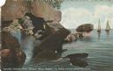
| Description: | View of several fisherman's homes on Bear Island, one of the islands that make up the Apostle Islands. An American flag is flying between buildings and a d... |
| Date: | |
|---|---|
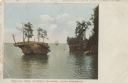
| Description: | View across water towards two schooners off the shore of Madeline Island, one of the islands that comprise the Apostle Islands in Lake Superior. Two large ... |

| Date: | 1884 |
|---|---|
| Description: | A detailed, hand-colored map of Wisconsin and the western portion of Michigan’s Upper Peninsula, which also includes an inset of Isle Royale in Lake Superi... |

| Date: | 1907 |
|---|---|
| Description: | A map of the eastern portion of the Apostle Islands group, and a detailed map of Gull Island showing the relief on the island, are included here, along wit... |

| Date: | 1990 |
|---|---|
| Description: | This tourism brochure of Ashland County, Wisconsin, from the Ashland Area Chamber of Commerce includes a map of the county showing tourist destinations and... |

| Date: | 1871 |
|---|---|
| Description: | Asaph Whittlesey arrived in Ashland in 1854, one of the earliest of the settlers who hoped the area would grow and make their fortunes. He drew this map of... |

| Date: | 1900 |
|---|---|
| Description: | This chart of the northern Apostle Islands and Lake Superior shoreline shows relief by contours and spot heights and depths by contours, gradient tints and... |

| Date: | 1871 |
|---|---|
| Description: | Asaph Whittlesey arrived in Ashland in 1854, one of the earliest of the settlers who hoped the area would grow and make their fortunes. He drew this map of... |

| Date: | 1888 |
|---|---|
| Description: | This map shows counties, lakes, railroads, and rivers. Lake Michigan, Lake Superior, and the Apostle Islands are labeled. A table of railroad lines with mi... |

| Date: | 1871 |
|---|---|
| Description: | This map shows railroads, canals, towns and some lighthouses. Areas of the company lands proper, tin, iron, gold & silver, silver islet, and lead are color... |

| Date: | 1906 |
|---|---|
| Description: | This map shows bays, creeks, railroads and rivers. Relief is shown by contours and spot heights. Depths are shown by contours, tints, and soundings. Includ... |
If you didn't find the material you searched for, our Library Reference Staff can help.
Call our reference desk at 608-264-6535 or email us at: