 Filter: Categories of Wisconsin Historical Images
Filter: FORMAT_TYPE of prints, photomechanical
Filter: Subject of transportation
Filter: Subject of attractions
Filter: Categories of Wisconsin Historical Images
Filter: FORMAT_TYPE of prints, photomechanical
Filter: Subject of transportation
Filter: Subject of attractions
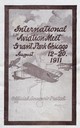
| Date: | 08 11 1911 |
|---|---|
| Description: | Souvenir postcard sent to Harriet O'Shea of Madison from an unidentified friend who attended the Chicago International Aviation Meet. The Chicago meet, whi... |
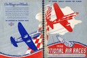
| Date: | 1939 |
|---|---|
| Description: | Back and front covers of the program for the 1939 National Air Races, with a special label acknowledging the role of Harry Bruno as publicist for the Bendi... |
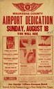
| Date: | 08 18 1935 |
|---|---|
| Description: | Poster advertising the air show held to mark the dedication of the airport in Waukesha, an event sponsored by the Waukesha Aviation Club. Present to dedica... |
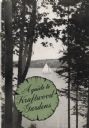
| Date: | |
|---|---|
| Description: | Cover of A guide to Kraftwood Gardens showing a view of a sailboat on Lake Machkinosiew (now Enterprise Lake) seen between trees. The publication's ... |
| Date: | 1948 |
|---|---|
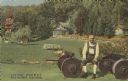
| Description: | Colorized postcard of a scene at Little Norway. A man sits on a wagon chassis. He is wearing an ethnic costume. Various buildings are visible surrounded by... |

| Date: | 1947 |
|---|---|
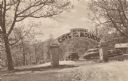
| Description: | Colorized postcard of the entrance to the Cave of the Mounds. A curved sign sits on two square stone pillars. The sign reads "Welcome, Cave of the Mounds, ... |
| Date: | |
|---|---|
| Description: | Postcard of the entrance to the Cave of the Mounds. A curved sign sits on two square stone pillars. The sign reads: "Welcome, Cave of the Mounds, Drive In.... |
| Date: | |
|---|---|
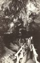
| Description: | Photographic postcard of Crystal Chandeliers above the Lake Bridge in the Cave of the Mounds. A group of visitors stand on a wooden walkway underneath the ... |

| Date: | 1936 |
|---|---|
| Description: | This colored road map shows automobile roads in Wisconsin as well as portions of nearby states. Information on the quality and type of any given road (pave... |

| Date: | 1937 |
|---|---|
| Description: | This blue-line map of Wisconsin shows two maps of Wisconsin and the surrounding area, with a railroad map on one side and a road map on the other. The rail... |

| Date: | 1966 |
|---|---|
| Description: | This colored road map shows automobile roads in Wisconsin as well as portions of nearby states. A map key indicates relative sizes of cities and towns. On ... |

| Date: | 1967 |
|---|---|
| Description: | This colored map published by the State Historical Society of Wisconsin shows key points of interest telling the story of Wisconsin's earliest settlement a... |

| Date: | 1970 |
|---|---|
| Description: | This colored map displays a brief description of tourist attractions in the state, as well as a grid of state parks and recreational facilities. There is a... |

| Date: | 1966 |
|---|---|
| Description: | This colored road map shows automobile roads in Wisconsin as well as portions of nearby states. Information on the quality and type of any road shown (inte... |

| Date: | 1971 |
|---|---|
| Description: | This colored map displays Wisconsin and bordering areas of Iowa, Minnesota, and Michigan. There is color-coding on the map to indicate National Forests, an... |

| Date: | 1973 |
|---|---|
| Description: | This colored map displays Wisconsin and bordering areas of Iowa, Minnesota, and Michigan. There is color-coding on the map to indicate National Forests, a... |

| Date: | 1975 |
|---|---|
| Description: | This colored road map of Wisconsin displays "Featured Points of Interest" and "Historical Points of Interest" in the state, including three color photograp... |

| Date: | 1973 |
|---|---|
| Description: | This map displays, in color, Wisconsin and bordering areas of Iowa, Minnesota, Illinois, and Michigan. At the bottom is a map key indicating road classifi... |

| Date: | 1976 |
|---|---|
| Description: | This color map displays Wisconsin and bordering areas of Iowa, Minnesota, Illinois, and Michigan. At the bottom is a map key indicating road classification... |

| Date: | 1976 |
|---|---|
| Description: | This colored map displays Wisconsin and portions of bordering states, including a detailed map of the Wisconsin Dells area. Surrounding the map are multipl... |
If you didn't find the material you searched for, our Library Reference Staff can help.
Call our reference desk at 608-264-6535 or email us at: