 Filter: Categories of Wisconsin Historical Images
Filter: FORMAT_TYPE of prints, photomechanical
Filter: Subject of transportation
Filter: Subject of health
Filter: Categories of Wisconsin Historical Images
Filter: FORMAT_TYPE of prints, photomechanical
Filter: Subject of transportation
Filter: Subject of health
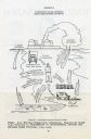
| Date: | 07 1976 |
|---|---|
| Description: | Diagram showing environmental means by which humans can be exposed to radiation from nuclear power plants. |

| Date: | 1879 |
|---|---|
| Description: | This map shows asylums, cemeteries, hospitals, parks, streets, and wards. Relief is shown by contours. Also included are manuscript annotations in pencil. ... |
If you didn't find the material you searched for, our Library Reference Staff can help.
Call our reference desk at 608-264-6535 or email us at: