 Filter: Categories of Wisconsin Historical Images
Filter: FORMAT_TYPE of prints, photomechanical
Filter: Subject of transportation
Filter: Subject of outdoor recreation
Filter: Categories of Wisconsin Historical Images
Filter: FORMAT_TYPE of prints, photomechanical
Filter: Subject of transportation
Filter: Subject of outdoor recreation
| Date: | |
|---|---|
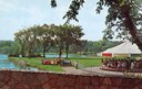
| Description: | View from a stone bridge towards Vilas Park, with children riding the carousel (merry-go-round) and a kiddie train adjacent to the lagoon. |
| Date: | 1931 |
|---|---|
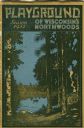
| Description: | Cover of a Wisconsin tourism pamphlet for the 1932 season. |

| Date: | 1925 |
|---|---|
| Description: | This brochure intended for tourists and shows resorts, lakes and railroads in northwestern Wisconsin and part of Michigan’s upper peninsula. Two inset maps... |

| Date: | 07 16 1949 |
|---|---|
| Description: | Advertising proof for International trucks, featuring a color illustration of a couple of boys waving at a passing semi-truck (tractor-trailer). Includes t... |

| Date: | 1958 |
|---|---|
| Description: | Includes images of Flambeau River State Forest and a description of, canoeing and recreational activities in, and general park and forest information about... |
| Date: | |
|---|---|
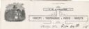
| Description: | Letterhead of the Price County Treasurer's office, with a three-quarter view of the county building, and people walking and children playing outside. Text ... |

| Date: | 1936 |
|---|---|
| Description: | This pictorial tourist map from the Wisconsin Conservation Commission depicts vacation activities and identifies tourist destinations throughout the state.... |

| Date: | 1949 |
|---|---|
| Description: | This 1949 tourism brochure for the Hayward region includes a directory of members of the Hayward Lakes Resort Association, color illustrations, descriptive... |

| Date: | 1964 |
|---|---|
| Description: | This 1964 maps shows roads, boat landings and marinas, campgrounds, canoe trails and portages, and lakes and streams in parts of Vilas, Oneida, and Iron co... |

| Date: | 1991 |
|---|---|
| Description: | This 1991 map of Burnett County, Wisconsin, shows Governor Knowles State Forest, wildlife areas, public hunting grounds, and other outdoor recreation facil... |
| Date: | 09 1895 |
|---|---|
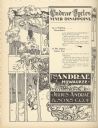
| Description: | Full page, engraved advertisement for Andrae Cycles. Depicts men and women bicycling on a path in a bucolic setting, in addition to text promoting bicycles... |

| Date: | 1967 |
|---|---|
| Description: | This tourist brochure for Forest County, Wisconsin, includes a 1967 road map of the county which identifies points of interest, a location map, descriptive... |
| Date: | 1896 |
|---|---|
| Description: | Masthead of the bicycling journal Pneumatic. |

| Date: | 1986 |
|---|---|
| Description: | This late 1980s map of Price County, Wisconsin, shows facilities and lands open for public recreation, hunter walking trails and ski trails, campgrounds, b... |

| Date: | 1928 |
|---|---|
| Description: | Illustrated map of points of interest, including University buildings, parks, athletic venues, fraternity and sorority houses, and state buildings. |
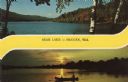
| Date: | |
|---|---|
| Description: | Two views of Bear Lake. The top is a daylight view with some fall color. The one below is at sunset, with two people in a canoe on the lake. Caption reads:... |

| Date: | |
|---|---|
| Description: | Colorized postcard view over water towards boats and boaters at a resort. In the background are people and boats near a pier. The resort is among trees on ... |

| Date: | 1855 |
|---|---|
| Description: | This bird's-eye-view map of Madison is looking north across Lake Monona. The map features two women and two men on a lookout on top of a building in the fo... |

| Date: | 1986 |
|---|---|
| Description: | Pictorial map showing businesses with phone numbers, roads, railroads, and parks. Includes text titled: "History of Portage County." |

| Date: | 1939 |
|---|---|
| Description: | This brochure was intended for tourists and shows resorts, lakes and railroads in northwestern Wisconsin and part of Michigan’s upper peninsula. Also inclu... |
If you didn't find the material you searched for, our Library Reference Staff can help.
Call our reference desk at 608-264-6535 or email us at: