 Filter: Categories of Wisconsin Historical Images
Filter: FORMAT_TYPE of prints, photomechanical
Filter: Subject of transportation
Filter: Subject of rural areas
Filter: Categories of Wisconsin Historical Images
Filter: FORMAT_TYPE of prints, photomechanical
Filter: Subject of transportation
Filter: Subject of rural areas
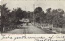
| Date: | 04 1906 |
|---|---|
| Description: | View of West Park Drive. Wooden railings line the road and a wooden walkway is on the right. A man wearing a cap is driving an automobile across the drive.... |

| Date: | 08 1909 |
|---|---|
| Description: | View of trees and dirt road in Oak Park. Caption reads: "Oak Park, Army Lake, Wis." |

| Date: | 09 24 1910 |
|---|---|
| Description: | View of several fisherman's homes on Bear Island, one of the islands that make up the Apostle Islands. An American flag is flying between buildings and a d... |
| Date: | |
|---|---|
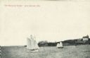
| Description: | View across water towards two schooners off the shore of Madeline Island, one of the islands that comprise the Apostle Islands in Lake Superior. Two large ... |

| Date: | 1911 |
|---|---|
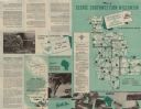
| Description: | This 1911 map shows the Post Office's rural routes in Racine County, Wisconsin, and portions of eastern Walworth and northern Kenosha counties. The locatio... |

| Date: | 1908 |
|---|---|
| Description: | Map shows townships and sections, landownership and acreages, rural routes, roads, railroads, creameries, churches, schools, and town halls. Sections appea... |

| Date: | 1911 |
|---|---|
| Description: | Map shows in blue roads, railroads, post offices, schools, houses, churches, and routes. The map includes a chart of "Explanation" that acts as a legend. T... |
| Date: | 1912 |
|---|---|
| Description: | Map shows roads, railroads, post offices, schools, houses, churches, routes, and post office collection boxes. The map includes a distant chart and explana... |

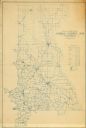
| Date: | 1910 |
|---|---|
| Description: | Map is a blueline print. Map shows United States postal routes for La Crosse County. A list of stations include: Bangor R R 1-3, Holmen R R 1-2, La Crosse ... |
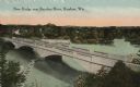
| Date: | 1919 |
|---|---|
| Description: | Colorized postcard of an elevated view of a concrete bridge over a river. There is a boat near wooden pilings that stretch from the shoreline to the center... |

| Date: | 1876 |
|---|---|
| Description: | A hand-colored map on six sheets, this map of Juneau County indicates the locations of townships and sections, landowners and acreages, roads, wagon roads,... |

| Date: | 1910 |
|---|---|
| Description: | Aerial view of the Wisconsin Masonic Home and Farm on Highway 18, thirty miles west of Milwaukee. |

| Date: | 1909 |
|---|---|
| Description: | Bird's-eye view of Lake Geneva from the south extending to Waukesha and Milwaukee in the north. Delavan Lake and Lake Como are identified. Several electric... |

| Date: | 1927 |
|---|---|
| Description: | This Blue line print map shows trade area boundaries, lakes, farm homes, railways, high schools, public highways, and townships. A symbol key is included i... |

| Date: | 1793 |
|---|---|
| Description: | Detailed topographical map of the Ohio River between Clarkville and Louisville. It shows plots of farmland, forest, islands, garden plots, houses, Fort Fe... |

| Date: | |
|---|---|
| Description: | Elevated view from hill of a farm and the surrounding landscape. Hills are in the distance. Caption reads: "Elroy, Wis." |
| Date: | 1953 |
|---|---|
| Description: | This map shows the locations of many scenic areas in La Crosse, Vernon, Crawford, Richland, Grant, and Iowa Counties. On the front side of the map, there i... |

| Date: | |
|---|---|
| Description: | Elevated view of a curving railroad bridge with a train approaching. The Rock River is below. Buildings are on the far bank on the right. Caption reads: "C... |
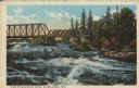
| Date: | 1914 |
|---|---|
| Description: | Text on front reads: "View on Wisconsin River, Rhinelander, Wis." A trestle railroad bridge crosses turbulent water on the Wisconsin River. The rocky shore... |
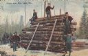
| Date: | 10 23 1909 |
|---|---|
| Description: | Text on front reads: "Scene Near Rice Lake, Wis." Five lumberjacks pose with a load of logs on a sled pulled by horses. Two skids lean against the logs. Th... |
If you didn't find the material you searched for, our Library Reference Staff can help.
Call our reference desk at 608-264-6535 or email us at: