 Filter: Categories of Wisconsin Historical Images
Filter: FORMAT_TYPE of prints, photomechanical
Filter: Subject of travel
Filter: Subject of water
Filter: Categories of Wisconsin Historical Images
Filter: FORMAT_TYPE of prints, photomechanical
Filter: Subject of travel
Filter: Subject of water
| Date: | |
|---|---|
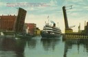
| Description: | Colorized view depicting the passenger excursion vessel, "Christopher Columbus," approaching the East Water Street Bridge. Caption reads: "Whaleback Steame... |
| Date: | 1832 |
|---|---|
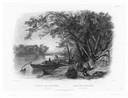
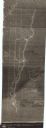
| Description: | Travellers setting up camp along the Missouri River. |

| Date: | 1892 |
|---|---|
| Description: | Bird's-eye view of the Columbian Exposition pavilions from the vantage point of Lake Michigan. Included is an inset of the Union Passenger Station (now Uni... |

| Date: | 1941 |
|---|---|
| Description: | Official highway map of Wisconsin, "the playground of the Midwest," showing the state transportation network prior to World War II. |

| Date: | 1934 |
|---|---|
| Description: | Tourist camp at Lakeside Park on Lake Winnebago. |

| Date: | 04 1971 |
|---|---|
| Description: | Poster featuring a stylized sun rising over the ocean, advertising spring break vacations to Nassau for University of Wisconsin faculty and students. |
| Date: | 1934 |
|---|---|
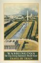
| Description: | An original lithograph promoting Washington, D.C. as "the city that every American should know," and to get there by way of train travel. The poster depict... |

| Date: | 1928 |
|---|---|
| Description: | An original New York Central Lines railway lithograph promoting Ashtabula Harbor, Lake Erie, as the location "Where Trainloads of Appalachian Coal are Exch... |
| Date: | 1935 |
|---|---|
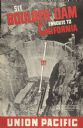
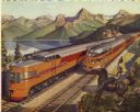
| Description: | An original lithograph promoting the Boulder Dam enroute to California via the Union Pacific Railway. The poster features an aerial photograph of the "Worl... |
| Date: | 1947 |
|---|---|
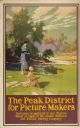
| Description: | An original colored lithograph advertising the London Midland and Scottish Railway Company, and promoting Haddon Hall and the Wye Valley as "The Peak Distr... |

| Date: | 1884 |
|---|---|
| Description: | Cover art for a pamphlet advertising The Apostle Islands and Lake Superior. The upper half of the artwork depicts a sunset view of Lake Superior, and the b... |

| Date: | 1858 |
|---|---|
| Description: | Front cover of a guide book describing Bayfield and an account of a pleasure tour to Lake Superior. The title is surrounded by a decorative border with flo... |
| Date: | 1946 |
|---|---|
| Description: | Reproduction of a painting depicting an Olympian Hiawatha locomotive and an Olympian Hiawatha observation car traveling in the western United States. A man... |

| Date: | 1987 |
|---|---|
| Description: | This pictorial map shows roads, bridges, local businesses with phone numbers, and public buildings. Relief is shown pictorially. Also included is a calen... |

| Date: | 1948 |
|---|---|
| Description: | This illustrated map shows major westward trails from 1785 to 1866: Old Oregon Trail and its deviations, Old Spanish Trail, Lewis and Clark route, Santa Fe... |
| Date: | 11 23 1930 |
|---|---|
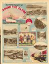
| Description: | Full page illustrated article in the Milwaukee Journal titled "The World Voyagers go Round The Globe by Radio and Roto." Included are photographs an... |
| Date: | 1840 |
|---|---|
| Description: | This map shows shows three routes; a route surveyed by Doty & Center, a route surveyed by inhabitants of East Milwaukee, and a route surveyed by inhabitant... |

| Date: | 1953 |
|---|---|
| Description: | This map shows locations of State Medical Society, nine medical facilities, two University of Wisconsin buildings, four transportation centers, and five ho... |

| Date: | 1975 |
|---|---|
| Description: | This map shows transportation routes taken by public transit. Includes a key to bus routes, schedule, and transit information. Includes labels for streets,... |

| Date: | 1935 |
|---|---|
| Description: | This colored road map comes with a map legend and explanation, as well as an index of cities and towns (and their populations) in Wisconsin. Information ab... |
If you didn't find the material you searched for, our Library Reference Staff can help.
Call our reference desk at 608-264-6535 or email us at: