 Filter: Categories of Wisconsin Historical Images
Filter: FORMAT_TYPE of prints, photomechanical
Filter: Subject of travel
Filter: Categories of Wisconsin Historical Images
Filter: FORMAT_TYPE of prints, photomechanical
Filter: Subject of travel
| Date: | 1955 |
|---|---|
| Description: | This colored road map shows automobile roads in Wisconsin as well as portions of nearby states. Information on the quality and type of any road shown (pave... |

| Date: | 1956 |
|---|---|
| Description: | This colored road map shows automobile roads in Wisconsin as well as portions of nearby states. The map is organized such that a single map of Wisconsin is... |

| Date: | 1957 |
|---|---|
| Description: | This colored road map shows automobile roads in Wisconsin as well as portions of nearby states. The map is organized such that a single map of Wisconsin is... |

| Date: | 1959 |
|---|---|
| Description: | This colored road map shows roads in Wisconsin as well as portions of nearby states. Information on the quality and type of any road shown (expressways, St... |

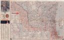
| Date: | 1962 |
|---|---|
| Description: | This colored road map shows roads in Wisconsin as well as portions of nearby states. The map is organized such that a single map of Wisconsin is divided on... |
| Date: | 1962 |
|---|---|
| Description: | This colored road map shows roads in Wisconsin as well as portions of nearby states. The map is organized such that a single map of Wisconsin is divided on... |

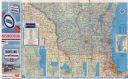
| Date: | 1962 |
|---|---|
| Description: | This tourist-oriented road map shows federal highways, state highways, county roads, and county lines in the "Blue Diamond Resort Area," a scenic space enc... |

| Date: | 1963 |
|---|---|
| Description: | This colored road map shows automobile roads in Wisconsin as well as portions of nearby states. The map is organized such that a single map of Wisconsin is... |
| Date: | 1963 |
|---|---|
| Description: | This colored road map shows automobile roads in Wisconsin as well as portions of nearby states. The map is organized such that a single map of Wisconsin is... |

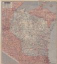
| Date: | 1965 |
|---|---|
| Description: | This colored road map shows automobile roads in Wisconsin as well as portions of nearby states. Information on the quality and type of any road shown (inte... |

| Date: | 1962 |
|---|---|
| Description: | This colored map represents "Tour #2" of a series of driving tours of the state published by the Sperry & Hutchinson Company, in order to "help you enjoy W... |

| Date: | 1952 |
|---|---|
| Description: | This colored map shows the entire state, along with counties in states bordering Wisconsin. There is a key to "Wisconsin Railroads," with initials identify... |

| Date: | 1949 |
|---|---|
| Description: | This multi-colored promotional map for recreational activities in the Hayward area includes a graphic of distances from Midwestern cities to Hayward, with ... |

| Date: | 1920 |
|---|---|
| Description: | Cover of an advertisement and timetable for the Peninsula & Northern Navigation Co. of Milwaukee. The S.S. United States and the S.S. Arizona... |
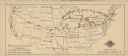
| Date: | 1924 |
|---|---|
| Description: | Map of the United States with tour route taken by the Chicago Civic Opera Company indicated in red. The company traveled on the Baltimore & Ohio Railroad S... |
| Date: | |
|---|---|
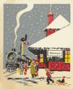
| Description: | Greeting card with a winter view of the Minocqua railroad station. A child is pulling another child on a sled through the snow, and two people are meeting ... |
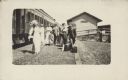
| Date: | 07 16 1913 |
|---|---|
| Description: | Photographic postcard of men, women and children standing near a railroad train car at the Hustler Depot. Handwritten note along with postcard reads: "Reve... |
| Date: | |
|---|---|
| Description: | Page 11 of a Freedom Primer about how the Freedom Democratic Party has grown in numbers. There are two simple drawings accompanying the text. One drawing ... |
If you didn't find the material you searched for, our Library Reference Staff can help.
Call our reference desk at 608-264-6535 or email us at: