 Filter: Categories of Wisconsin Historical Images
Filter: FORMAT_TYPE of prints, photomechanical
Filter: Subject of water-power
Filter: Categories of Wisconsin Historical Images
Filter: FORMAT_TYPE of prints, photomechanical
Filter: Subject of water-power
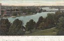
| Date: | 1905 |
|---|---|
| Description: | View from hill looking down towards the Fox river. Caption reads: "Fox River Water Power, Appleton, Wis." |
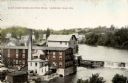
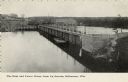
| Date: | 1905 |
|---|---|
| Description: | View of the dam and power plant over the river, with smokestacks in the background. Caption reads: "The Dam, Beloit, Wis." |
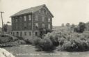
| Date: | 1910 |
|---|---|
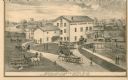
| Description: | Elevated view of the White Wagon Works and Rock Mills. Caption reads: "White Wagon Works and Rock Mills, Sheboygan Falls, Wis." |

| Date: | 1910 |
|---|---|
| Description: | Elevated view from hill toward the building which has two large smokestacks. The Lake Michigan shoreline is on the left. In front is a landscaped area with... |
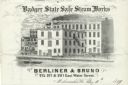
| Date: | |
|---|---|
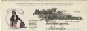
| Description: | Letterhead of the Berliner & Bruno's Badger State Safe Steam Works of Milwaukee, Wisconsin, with a three-quarter view of the steam works and depot, people ... |
| Date: | |
|---|---|
| Description: | Letterhead of the H. Mooers Company of Milwaukee, Wisconsin, a steam and hot water heating supplier, with a pipe and valve, the name of the company printed... |
| Date: | |
|---|---|
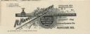
| Description: | Letterhead of National Blower Works of Milwaukee, Wisconsin, manufacturers of "Steam Hot Blast Apparatus." On the left is an Uncle Sam figure pointing to a... |

| Date: | |
|---|---|
| Description: | Letterhead of James Sheriffs of Milwaukee, Wisconsin, manufacturer of "Propeller Wheels, Steam Engines, Boilers, Mill Machinery, Iron and Brass Castings," ... |

| Date: | 1915 |
|---|---|
| Description: | This 1915 map of Lincoln County, Wisconsin, shows the township and range grid, towns, cities and villages, lakes and streams, residences, churches, school ... |

| Date: | 1892 |
|---|---|
| Description: | This map shows the dams and locks of the Fox River between Neenah, in Winnebago County, Wisconsin, and Kaukauna, in Outagamie County. The cities and villag... |

| Date: | 1919 |
|---|---|
| Description: | Colorized postcard view of the water works, smokestack and water tower. People are lounging under the trees in front. Caption reads: "Water Works, Beloit, ... |
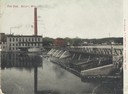
| Date: | 1908 |
|---|---|
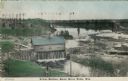
| Description: | Colorized photographic postcard of an elevated view of the power station next to the river. A bridge is in the background. Caption reads: "Power Station, B... |
| Date: | 1873 |
|---|---|
| Description: | A print depicts activity around the three-story, wood frame Geneva Flouring Mills. Horse-drawn wagons, pedestrians, and a boy rolling a hoop create a busy ... |

| Date: | 1891 |
|---|---|
| Description: | This blueprint manuscript map shows land owned by Kaukauna Water Power Co., Green Bay & Mississippi Canal Co., A.W. Patten, N.M. Edwards, and M.J. Meade. P... |

| Date: | |
|---|---|
| Description: | View across water towards the Pumping Station on the riverfront. Central Jefferson is in the background. There are billboards on the right, with one that r... |
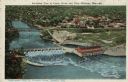
| Date: | 1924 |
|---|---|
| Description: | Illustration based on an aerial photograph of a powerhouse and dam on the Wisconsin River. A railroad bridge is upriver. The city of Kilbourn (now Wisconsi... |
| Date: | |
|---|---|
| Description: | Slightly elevated view of the dam and power house from across the Wisconsin River. Caption reads: "Dam and Power House from Up Stream, Kilbourne [sic], Wis... |

| Date: | |
|---|---|
| Description: | Exterior view of the water works building. Flowers are planted along the front, and lampposts are flanking the entrance. Caption reads: "Water Works, La Cr... |
| Date: | 1950 |
|---|---|
| Description: | View across water towards the Historic Monticello Woolen Mill. There are many windows on the mill building, and some of them are open. Other buildings are ... |
If you didn't find the material you searched for, our Library Reference Staff can help.
Call our reference desk at 608-264-6535 or email us at:
