 Filter: Categories of Wisconsin Historical Images
Filter: FORMAT_TYPE of prints, photomechanical
Filter: Subject of wisconsin river (wis.)
Filter: Creator Name of Unknown
Filter: Categories of Wisconsin Historical Images
Filter: FORMAT_TYPE of prints, photomechanical
Filter: Subject of wisconsin river (wis.)
Filter: Creator Name of Unknown

| Date: | 1861 |
|---|---|
| Description: | Drawn the first year of the Civil War, this colored 1861 map of Dane County shows its towns, cities and lakes. It includes insets of the wards of Madison a... |

| Date: | 1879 |
|---|---|
| Description: | This map is a bird's-eye view of Wausau, the County Seat of Marathon County. The map features an index of points of interest. |

| Date: | 1928 |
|---|---|
| Description: | "The Dells," a brochure issued by the Chicago, Milwaukee & St. Paul and Pacific Railroad to advertise the Wisconsin Dells, a destination only five hours fr... |

| Date: | 1906 |
|---|---|
| Description: | Promotional brochure for the Wisconsin Dells (then known as Kilbourn) issued by the Chicago, Milwaukee & St. Paul Railway. The railroad illustrated many of... |
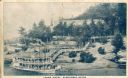
| Date: | 1910 |
|---|---|
| Description: | Elevated view across water toward the Larks Hotel and ferry. Caption reads: "Larks Hotel, Wisconsin Dells." |

| Date: | 1905 |
|---|---|
| Description: | View across water toward East Hill. Caption reads: "East Hill, from Depot Grounds, Wausau, Wis." |

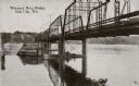
| Date: | 1910 |
|---|---|
| Description: | View across grass towards a wagon bridge on the left crossing the Wisconsin River at Stevens Point. Caption reads: "Wagon Bridge, across Wisconsin River, S... |
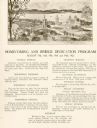
| Date: | 1922 |
|---|---|
| Description: | Homecoming and bridge dedication program, featuring an image of the approach to the Wisconsin River Bridge, and a listing of the celebration's planned even... |
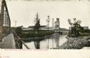
| Date: | 1910 |
|---|---|
| Description: | View from below along the left side of the Wisconsin River bridge. Tree-covered hills are on the opposite shoreline. Caption reads: "Wisconsin River Bridge... |
| Date: | 1910 |
|---|---|
| Description: | View from bridge looking towards the paper mill and railroad bridge on the Wisconsin River outside of Rhinelander. Caption reads: "Wisconsin River and Pape... |

| Date: | 1910 |
|---|---|
| Description: | This was the first bridge built across the Wisconsin River, constructed about 1850, although it was not opened to traffic until 1852. It was torn down in 1... |
| Date: | |
|---|---|
| Description: | Black and white postcard of an elevated view of the Old Covered Bridge crossing the Wisconsin River. The bridge is on the left and the river is on the righ... |
| Date: | |
|---|---|
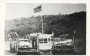
| Description: | The Merrimac ferry "Colsac" with an American flag. |
| Date: | |
|---|---|
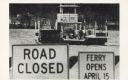
| Description: | The Merrimac ferry "Colsac II" is seen on the Wisconsin River behind two signs. The signs read, "Road Closed" and "Ferry Opens April 15". |
| Date: | |
|---|---|
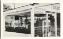
| Description: | A close view of the Merrimac ferry "Colsac I" with a sign reading, "Stop Your Motor When Ferry Is Moving". |
| Date: | |
|---|---|
| Description: | Automobiles line up to wait for the Merrimac ferry "Colsac". |
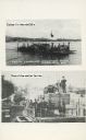
| Date: | |
|---|---|
| Description: | Two images of ferries as printed on a postcard. The top image is the ferry "Colsac" on the Wisconsin River. The bottom image is simply described as an earl... |

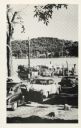
| Date: | |
|---|---|
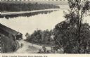
| Description: | The top elevated view shows the Wisconsin River with several boats. The bottom view includes the river and the Northwestern Railroad bridge from the shorel... |

| Date: | 1991 |
|---|---|
| Description: | This canoe guide depicts the Wisconsin River from just north of Prairie du Sac to near Spring Green. Landmarks and points of interest are identified and de... |

| Date: | 1900 |
|---|---|
| Description: | A map of Wisconsin, eastern Minnesota and Iowa, northern Iowa, and Michigan’s Upper Peninsula, showing railway lines, with those marked with heavy red line... |
If you didn't find the material you searched for, our Library Reference Staff can help.
Call our reference desk at 608-264-6535 or email us at: