 Filter: Categories of Wisconsin Historical Images
Filter: FORMAT_TYPE of prints, photomechanical
Filter: Subject of wisconsin river (wis.)
Filter: County of Columbia
Filter: Categories of Wisconsin Historical Images
Filter: FORMAT_TYPE of prints, photomechanical
Filter: Subject of wisconsin river (wis.)
Filter: County of Columbia
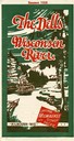
| Date: | 1928 |
|---|---|
| Description: | "The Dells," a brochure issued by the Chicago, Milwaukee & St. Paul and Pacific Railroad to advertise the Wisconsin Dells, a destination only five hours fr... |

| Date: | 1906 |
|---|---|
| Description: | Promotional brochure for the Wisconsin Dells (then known as Kilbourn) issued by the Chicago, Milwaukee & St. Paul Railway. The railroad illustrated many of... |
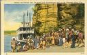
| Date: | |
|---|---|
| Description: | Winnebago (Ho-Chunk) Indians posing in front of the steamboat Winnebago near the Stand Rock Amphitheater. This is where the Stand Rock Indian Ceremo... |
| Date: | 1910 |
|---|---|
| Description: | Elevated view across water toward the Larks Hotel and ferry. Caption reads: "Larks Hotel, Wisconsin Dells." |
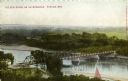
| Date: | 1900 |
|---|---|
| Description: | Elevated view of a bridge over the Wisconsin River. Caption reads: "The New Bridge on the Wisconsin, Portage, Wis." |
| Date: | |
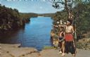
|---|---|
| Description: | A woman in an Indian dress and headband sits at High Rock in the Upper Dells looking over the Wisconsin River at a tour boat. |
| Date: | |
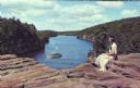
|---|---|
| Description: | An Indian man and boy in native garb stand on High Rock with the Wisconsin River in the background. The man is pointing towards the left and holding a bow ... |

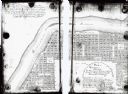
| Date: | 1854 |
|---|---|
| Description: | This map is ink and watercolor on tracing cloth and shows lot and block numbers, streets, a park, and depots. Some lots are colored red or blue and some in... |
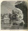
| Date: | |
|---|---|
| Description: | Engraved view of "The Jaws" in the Wisconsin Dells. |

| Date: | 1940 |
|---|---|
| Description: | This map of the Wisconsin Dells shows original plats and various additions. Some streets are labeled as is the Wisconsin River. The map was originally crea... |
| Date: | 1836 |
|---|---|
| Description: | This map shows proposed lot and block numbers for a paper city located in township 10 north, range 7 east, Wisconsin Territory, now the Town of West Point,... |

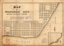
| Date: | 1856 |
|---|---|
| Description: | This plat shows block and lot numbers and land reserved for a railroad and passenger depot. The map includes certifications and registration. Kilbourn City... |

| Date: | 1920 |
|---|---|
| Description: | This street map was likely given out by the Rebholz Company: Clothiers and Furnishers. The map shows labeled streets, train tracks, Silver Lake, Mud Lake, ... |

| Date: | |
|---|---|
| Description: | This plat map shows lots and block numbers of a paper city located on the Wisconsin River and Hasting’s Creek, in what is now the Town of West Point, Colum... |

| Date: | 1836 |
|---|---|
| Description: | This map shows lot and block numbers, streets, a proposed canal basin, Fort Winnebago, and the Wisconsin and Fox Rivers. Relief is shown by hachures and no... |

| Date: | 1855 |
|---|---|
| Description: | This map shows landownership, lot and block numbers, streets, a canal, bridges, Fort Winnebago, the Wisconsin River, and the Fox River. Relief is shown by ... |
| Date: | 1900 |
|---|---|
| Description: | This map shows lots, public squares, landing, streets, and promenade of a paper city on a site now in the Town of West Point, Columbia County. The Wisconsi... |
| Date: | 1920 |
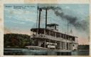
|---|---|
| Description: | View across river towards the rear of the excursion boat "Apollo" in the narrows of the dells. Rock formations are on the left. Caption reads: "In the Narr... |
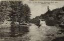
| Date: | |
|---|---|
| Description: | View across water towards a two-level flat bottom steam excursion boat. Tourists are on the upper deck. In the background is a tree-lined shoreline. Captio... |
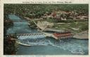
| Date: | 1924 |
|---|---|
| Description: | Illustration based on an aerial photograph of a powerhouse and dam on the Wisconsin River. A railroad bridge is upriver. The city of Kilbourn (now Wisconsi... |
If you didn't find the material you searched for, our Library Reference Staff can help.
Call our reference desk at 608-264-6535 or email us at: