 Filter: Categories of Wisconsin Historical Images
Filter: FORMAT_TYPE of prints, photomechanical
Filter: Subject of wisconsin river (wis.)
Filter: Subject of engraving
Filter: Categories of Wisconsin Historical Images
Filter: FORMAT_TYPE of prints, photomechanical
Filter: Subject of wisconsin river (wis.)
Filter: Subject of engraving
| Date: | |
|---|---|
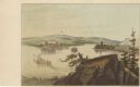
| Description: | Drawing of the mouth of the Wisconsin River from a scenic overlook depicting a steamboat in the distance. Print is part of a series collected in Lewis' "Da... |
| Date: | |
|---|---|
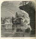
| Description: | Engraved view of "The Jaws" in the Wisconsin Dells. |

| Date: | 1755 |
|---|---|
| Description: | Map of the Great Lakes region during the French and Indian War. It shows in great detail the territories, borders and boundary lines, Native American tribe... |
If you didn't find the material you searched for, our Library Reference Staff can help.
Call our reference desk at 608-264-6535 or email us at: