 Filter: Categories of Wisconsin Historical Images
Filter: FORMAT_TYPE of prints, photomechanical
Filter: Subject of wisconsin river (wis.)
Filter: Subject of indians of north america
Filter: Categories of Wisconsin Historical Images
Filter: FORMAT_TYPE of prints, photomechanical
Filter: Subject of wisconsin river (wis.)
Filter: Subject of indians of north america
| Date: | |
|---|---|
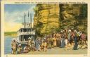
| Description: | Winnebago (Ho-Chunk) Indians posing in front of the steamboat Winnebago near the Stand Rock Amphitheater. This is where the Stand Rock Indian Ceremo... |
| Date: | |
|---|---|
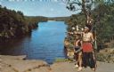
| Description: | An Indian man and boy in native garb stand on High Rock with the Wisconsin River in the background. The man is pointing towards the left and holding a bow ... |

| Date: | 1899 |
|---|---|
| Description: | This color map, originally published in the Smithsonian Institution Bureau of American Ethnology's 18th annual report, shows the Indian land cessions in Wi... |

| Date: | 1900 |
|---|---|
| Description: | A map of Wisconsin, eastern Minnesota and Iowa, northern Iowa, and Michigan’s Upper Peninsula, showing railway lines, with those marked with heavy red line... |

| Date: | 1846 |
|---|---|
| Description: | A map of Wisconsin and a portion of Minnesota that show the township surveys in progress in portions of the Saint Croix River region and in central Wiscons... |

| Date: | 1838 |
|---|---|
| Description: | This map is a development plat that shows street names, numbered blocks and lots, and small farm lot owners. Included on the right of the map is a large am... |

| Date: | 1853 |
|---|---|
| Description: | This map shows camps, forts, logging camps, lakes, roads, railroads, the Wisconsin River, and Lac Du Flambeau Indian Reservation. Some points of interest a... |

| Date: | 1760 |
|---|---|
| Description: | This map shows lakes, rivers, forts, settlements, and Native American tribal territory. The southern boundary of the Hudsons Bay Company is labeled. Relief... |

| Date: | 1837 |
|---|---|
| Description: | This map shows planned military posts/depots, barracks, rivers, lakes, roads, existing forts, and land assigned to various Indian tribes. Arkansas, Illinoi... |

| Date: | 1755 |
|---|---|
| Description: | Map of the Great Lakes region during the French and Indian War. It shows in great detail the territories, borders and boundary lines, Native American tribe... |

| Date: | 1930 |
|---|---|
| Description: | Text on front reads: "Wisconsin Dells." A Large Letter Postcard with a background illustration of Stand Rock and a Native American in a canoe, with a Nativ... |

| Date: | 1947 |
|---|---|
| Description: | Text on front reads: "Greetings From Wisconsin Dells, Wisconsin." A Large Letter Postcard with a blue and orange background, each letter is filled with a s... |

| Date: | 1955 |
|---|---|
| Description: | Text reads: "Wisconsin Dells. 18 Miniature Postcards from Original Photographs. Stand Rock. Indian Chief." A souvenir view folder containing a group of 18 ... |
| Date: | 1930 |
|---|---|
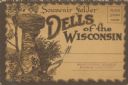
| Description: | Text reads: "Souvenir Folder. Dells of the Wisconsin." The mailing side/front of a souvenir view folder containing eleven accordion folded, double-sided co... |

| Date: | 1936 |
|---|---|
| Description: | Text reads: "Indians of Wisconsin Dells. The Sentinel." The mailing side of a souvenir view folder containing eight accordion folded, double-sided color im... |

| Date: | 1950 |
|---|---|
| Description: | Text on reverse reads: "At Demon's Anvil, Wisconsin Dells, Wis." A Native American woman and man pose in front of Demon's Anvil wearing indigenous clothing... |

| Date: | 1920 |
|---|---|
| Description: | Text on front reads: "Winnebago Indians at Demon's Anvil, Dells of the Wisconsin River." On reverse: "Winnebago Indians at Demon's Anvil. Each summer some ... |

| Date: | 1969 |
|---|---|
| Description: | A map of Wisconsin from The Atlas of the Eight Counties of Forest, Florence, Iron, Langlade, Lincoln, Oneida, Price, Vilas. The map shows rivers and a vari... |
If you didn't find the material you searched for, our Library Reference Staff can help.
Call our reference desk at 608-264-6535 or email us at: