 Filter: Categories of Wisconsin Historical Images
Filter: FORMAT_TYPE of prints, photomechanical
Filter: Subject of wisconsin river (wis.)
Filter: Subject of landforms
Filter: Categories of Wisconsin Historical Images
Filter: FORMAT_TYPE of prints, photomechanical
Filter: Subject of wisconsin river (wis.)
Filter: Subject of landforms

| Date: | 1868 |
|---|---|
| Description: | Showing the counties, towns and railroads. Partly colored. Scale: 1 inch = 20 miles. |
| Date: | |
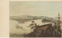
|---|---|
| Description: | Drawing of the mouth of the Wisconsin River from a scenic overlook depicting a steamboat in the distance. Print is part of a series collected in Lewis' "Da... |
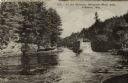
| Date: | 1920 |
|---|---|
| Description: | View across river towards the rear of the excursion boat "Apollo" in the narrows of the dells. Rock formations are on the left. Caption reads: "In the Narr... |

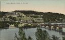
| Date: | |
|---|---|
| Description: | Aerial view of a hotel with multiple buildings near a bend in the Wisconsin River. A paddle-wheel steamer is heading toward the Dells. Caption reads: "Hote... |

| Date: | |
|---|---|
| Description: | Illustration of a bluff at the Dells, with a woman is sitting on the top near a tree. There are bluffs on the other side of the river in the background.Cap... |
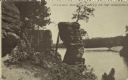
| Date: | 07 09 1911 |
|---|---|
| Description: | Text on front reads: "Chimney Rock, Dells of the Wisconsin." The rock formation Chimney Rock overhanging the Wisconsin River. Bluffs are on the left and th... |
| Date: | 1910 |
|---|---|
| Description: | Text on front reads: "Wagon Bridge, Prairie Du Sac, Wis." A long structure over the Wisconsin River. Buildings, bluffs and trees can be seen beyond the far... |
If you didn't find the material you searched for, our Library Reference Staff can help.
Call our reference desk at 608-264-6535 or email us at: