 Filter: Categories of Wisconsin Historical Images
Filter: FORMAT_TYPE of prints, photomechanical
Filter: Subject of wisconsin river (wis.)
Filter: Categories of Wisconsin Historical Images
Filter: FORMAT_TYPE of prints, photomechanical
Filter: Subject of wisconsin river (wis.)

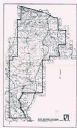
| Date: | 1868 |
|---|---|
| Description: | This map shows the configurations of the counties, communities, railroads and projected railroads, mines, shipping routes, and labeled rivers and lakes. Po... |
| Date: | 2013 |
|---|---|
| Description: | This map shows hydroelectric dams, natural-lake and man-made reservoirs, the Wisconsin River and its tributaries, and the Wisconsin River Drainage Basin. T... |
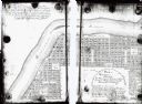
| Date: | 1900 |
|---|---|
| Description: | This map shows lots, public squares, landing, streets, and promenade of a paper city on a site now in the Town of West Point, Columbia County. The Wisconsi... |
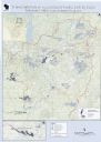
| Date: | 1976 |
|---|---|
| Description: | This map shows Wisconsin River Watershed, adjacent watersheds, and railroads in parts of Vilas, Oneida, Forest, Lincoln, Langlade, Marathon, Wood, Portage,... |
| Date: | 1999 |
|---|---|
| Description: | This map shows the best places to view bald eagles and areas to avoid when watching for eagles. The back of the map includes text and illustrations. |

| Date: | 1755 |
|---|---|
| Description: | Map of the Great Lakes region during the French and Indian War. It shows in great detail the territories, borders and boundary lines, Native American tribe... |

| Date: | 1935 |
|---|---|
| Description: | This road map shows automobile routes across the state of Wisconsin. Advertisements for various hotels are featured along the bottom edge of the map, while... |
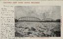
| Date: | 1907 |
|---|---|
| Description: | View of an ice jam near a Grand Rapids bridge in the Wisconsin River. Caption at top reads: "Greetings from Grand Rapids, Wis." Caption at bottom reads: "I... |

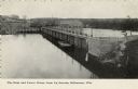
| Date: | 1910 |
|---|---|
| Description: | View down the tracks through the railroad bridge over the Wisconsin River. There is a warning sign on the right at the entrance. Caption reads: "Grand Rapi... |

| Date: | |
|---|---|
| Description: | Elevated view of the Grand Avenue Bridge. A horse and wagon is coming across the bridge, and pedestrians are crossing on the walkway. There is a post offic... |

| Date: | |
|---|---|
| Description: | View across water towards a bluff along the Wisconsin River. Caption reads: "Phoebie Point on the Wisconsin River, Hillside, Wis." |

| Date: | 1901 |
|---|---|
| Description: | A Sanborn map of Tomahawk featuring the Bay Mill Company's lumber yard. |
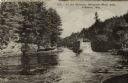
| Date: | 1920 |
|---|---|
| Description: | View across river towards the rear of the excursion boat "Apollo" in the narrows of the dells. Rock formations are on the left. Caption reads: "In the Narr... |
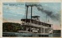
| Date: | |
|---|---|
| Description: | View across water towards a two-level flat bottom steam excursion boat. Tourists are on the upper deck. In the background is a tree-lined shoreline. Captio... |
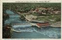
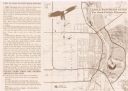
| Date: | 1924 |
|---|---|
| Description: | Illustration based on an aerial photograph of a powerhouse and dam on the Wisconsin River. A railroad bridge is upriver. The city of Kilbourn (now Wisconsi... |
| Date: | |
|---|---|
| Description: | Slightly elevated view of the dam and power house from across the Wisconsin River. Caption reads: "Dam and Power House from Up Stream, Kilbourne [sic], Wis... |

| Date: | |
|---|---|
| Description: | Aerial view of a hotel with multiple buildings near a bend in the Wisconsin River. A paddle-wheel steamer is heading toward the Dells. Caption reads: "Hote... |

| Date: | |
|---|---|
| Description: | Illustration of a bluff at the Dells, with a woman is sitting on the top near a tree. There are bluffs on the other side of the river in the background.Cap... |

| Date: | |
|---|---|
| Description: | Colorized postcard view of the railroad bridge over the Wisconsin River at Kilbourn. A canoe is along the shoreline in the foreground, and excursion boats ... |

| Date: | |
|---|---|
| Description: | Colortone postcard of boats near the shore, and a building in the distance. Postcard was sent to Mr. William Kruschke of Burnett Jc., from Otto Young. Capt... |
If you didn't find the material you searched for, our Library Reference Staff can help.
Call our reference desk at 608-264-6535 or email us at: