Filter: Categories of Wisconsin Historical Images
Filter: FORMAT_TYPE of prints, photomechanical
Filter: Subject of wisconsin river (wis.)
Filter: Categories of Wisconsin Historical Images
Filter: FORMAT_TYPE of prints, photomechanical
Filter: Subject of wisconsin river (wis.)
| Date: | 1910 |
|---|---|
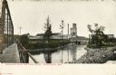
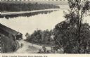
| Description: | View from bridge looking towards the paper mill and railroad bridge on the Wisconsin River outside of Rhinelander. Caption reads: "Wisconsin River and Pape... |
| Date: | |
|---|---|
| Description: | Geological map. |
| Date: | 1891 |
|---|---|
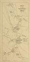
| Description: | This late 19th century map of the Dells of the Wisconsin River shows the geographic features and topography of the area. Kilbourn City (present day Wiscons... |

| Date: | 1840 |
|---|---|
| Description: | This map, one of a series made by Thomas Jefferson Cram of the U.S. Topographical Engineers from personal surveys, shows the portage connecting the Wiskons... |

| Date: | 1868 |
|---|---|
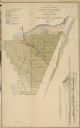
| Description: | Showing the counties, towns and railroads. Partly colored. Scale: 1 inch = 20 miles. |

| Date: | 1910 |
|---|---|
| Description: | This was the first bridge built across the Wisconsin River, constructed about 1850, although it was not opened to traffic until 1852. It was torn down in 1... |
| Date: | 1900 |
|---|---|
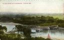
| Description: | Elevated view of a bridge over the Wisconsin River. Caption reads: "The New Bridge on the Wisconsin, Portage, Wis." |

| Date: | 1950 |
|---|---|
| Description: | Aerial view of the Highway 21 bridge and Petenwell Dam on the Wisconsin River. |

| Date: | 1828 |
|---|---|
| Description: | Plat of the Private Claims at Prairie Du Chien. |
| Date: | |
|---|---|
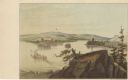
| Description: | Drawing of the mouth of the Wisconsin River from a scenic overlook depicting a steamboat in the distance. Print is part of a series collected in Lewis' "Da... |

| Date: | 1896 |
|---|---|
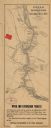
| Description: | Section 5 of 12, this bicycle road map features Wisconsin bicycle routes in the counties of La Crosse, Monroe, Vernon, Crawford, Richland, Sauk, Juneau, an... |

| Date: | 1913 |
|---|---|
| Description: | A wall atlas of Sauk County, Wisconsin, displaying its 22 towns. On the left side are advertisements for local businesses. |

| Date: | 1878 |
|---|---|
| Description: | Illustrated map of Crawford County. On the bottom right is an inset of a group of people near a train on a railroad track. |

| Date: | 1936 |
|---|---|
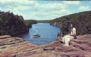
| Description: | A view of the Dells of the Wisconsin River, with two people walking down a long dock/walkway leading to a boat. |
| Date: | |
|---|---|
| Description: | Black and white postcard of an elevated view of the Old Covered Bridge crossing the Wisconsin River. The bridge is on the left and the river is on the righ... |
| Date: | |
|---|---|
| Description: | A woman in an Indian dress and headband sits at High Rock in the Upper Dells looking over the Wisconsin River at a tour boat. |
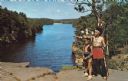
| Date: | |
|---|---|
| Description: | An Indian man and boy in native garb stand on High Rock with the Wisconsin River in the background. The man is pointing towards the left and holding a bow ... |
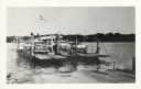
| Date: | |
|---|---|
| Description: | The Merrimac ferry loaded with automobiles. There is an American flag flying on the ferry. |
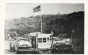
| Date: | |
|---|---|
| Description: | The Merrimac ferry "Colsac" with an American flag. |
If you didn't find the material you searched for, our Library Reference Staff can help.
Call our reference desk at 608-264-6535 or email us at: