Filter: Categories of Wisconsin Historical Images
Filter: FULL_DATE of 1832
Filter: Categories of Wisconsin Historical Images
Filter: FULL_DATE of 1832
| Date: | 1832 |
|---|---|
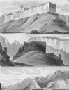
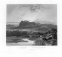
| Description: | Remarkable hills on the Upper Missouri River (views 10, 11, and 12) |
| Date: | 1832 |
|---|---|
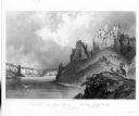
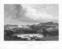
| Description: | View of the Stone Walls on the Upper Missouri River. Includes herd of bighorn sheep. |
| Date: | 1832 |
|---|---|
| Description: | Herd of Bison, on the Upper Missouri River. |
| Date: | 1832 |
|---|---|
| Description: | The Elkhorn Pyramid, on the Upper Missouri River. Passing Indians would add horns to the pyramid, and sometimes add red marks to the horns to indicate the ... |
| Date: | 1832 |
|---|---|
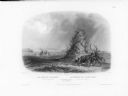
| Description: | The White Castles, on the Upper Missouri River. |
| Date: | 1832 |
|---|---|
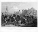
| Description: | Bison-Dance of the Mandan Indians in front of their medicine lodge in Mih-Tutta-Hangkush. |

| Date: | 1832 |
|---|---|
| Description: | Hand-drawn map in two parts of the route of Governor J.D. Doty. Probably made by Doty in 1832 as a result of his travels with Alexander J. Center. |
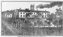
| Date: | 1832 |
|---|---|
| Description: | People work in the garden at the Protestant Episcopal Mission Buildings. |

| Date: | 1832 |
|---|---|
| Description: | Route of Military Road from Fort Crawford to Fort Howard. Map shows beginning of route at Fort Crawford. |

| Date: | 1832 |
|---|---|
| Description: | A hand-drawn map showing the survey of Township number 4, Range number 5, West Fourth Principal Meridian, which is parts of the present day towns of Glen H... |
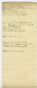
| Date: | 1832 |
|---|---|
| Description: | Page from the handwritten index to Lapham's Notes and accounts of canals, particularly the Ohio Canal near Portsmouth, 1830-1832. |

| Date: | 1832 |
|---|---|
| Description: | This map shows lot and block numbers, as well as the location of a shot tower, houses, stores, and barns. The map is oriented with the north to the left. T... |
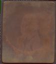
| Date: | 1832 |
|---|---|
| Description: | Copper plate physiognotrace of Carsten Tank, the father of Nils Otto Tank of Green Bay, Wisconsin. Subject faces left (proper right) wearing a coat, tie, a... |
If you didn't find the material you searched for, our Library Reference Staff can help.
Call our reference desk at 608-264-6535 or email us at: