 Filter: Categories of Wisconsin Historical Images
Filter: FULL_DATE of 1835
Filter: Creator Name of Unknown
Filter: Year of 1800-1899
Filter: Categories of Wisconsin Historical Images
Filter: FULL_DATE of 1835
Filter: Creator Name of Unknown
Filter: Year of 1800-1899
| Date: | 1835 |
|---|---|
| Description: | Engraving entitled "Tomb of Washington--Mount Vernon". |
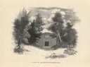
| Date: | 1835 |
|---|---|
| Description: | Drawing of the Stockbridge Indian mission. |

| Date: | 1835 |
|---|---|
| Description: | Constructed for the Topographical Bureau [Wash.], 1835. Scale: 16 miles to 1 inch. Map of a portion of the Indian country lying east and west of the Missis... |

| Date: | 1835 |
|---|---|
| Description: | Two-story home with sloping roof. One man is whipping a team of eight cattle while another man drives the plow behind them. To the left stands a man near a... |

| Date: | 1835 |
|---|---|
| Description: | Plat for a proposed Sinsinawa City (never built), in Grant County, Wis. When it became clear in the mid-1830s that Wisconsin Territory would be established... |

| Date: | 1835 |
|---|---|
| Description: | This manuscript map of Dane County, Wisconsin, from the first half of the 19th century shows the township and range grid, sections, cities and villages bot... |

| Date: | 1835 |
|---|---|
| Description: | These maps of the towns of Westport, Madison, and Blooming Grove, Dane County, Wisconsin, show sections, roads, trails, lakes and streams, and wetlands fro... |

| Date: | 1835 |
|---|---|
| Description: | This map is pen-and-ink on paper. The map shows landowners in "Milwalky" or present day Milwaukee. Includes "list of property offered to Mr. Walker". The m... |

| Date: | 1835 |
|---|---|
| Description: | An illustration of three men sitting at a table in a saloon on a steamboat. |
If you didn't find the material you searched for, our Library Reference Staff can help.
Call our reference desk at 608-264-6535 or email us at: