 Filter: Categories of Wisconsin Historical Images
Filter: FULL_DATE of 1835
Filter: Subject of indians of north america
Filter: Creator Name of Unknown
Filter: Categories of Wisconsin Historical Images
Filter: FULL_DATE of 1835
Filter: Subject of indians of north america
Filter: Creator Name of Unknown
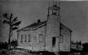
| Date: | 1835 |
|---|---|
| Description: | Drawing of the Stockbridge Indian mission. |

| Date: | 1835 |
|---|---|
| Description: | Constructed for the Topographical Bureau [Wash.], 1835. Scale: 16 miles to 1 inch. Map of a portion of the Indian country lying east and west of the Missis... |
If you didn't find the material you searched for, our Library Reference Staff can help.
Call our reference desk at 608-264-6535 or email us at: