 Filter: Categories of Wisconsin Historical Images
Filter: FULL_DATE of 1836
Filter: Creator Name of Unknown
Filter: Categories of Wisconsin Historical Images
Filter: FULL_DATE of 1836
Filter: Creator Name of Unknown

| Date: | 1836 |
|---|---|
| Description: | Map of all Dane County and eastern towns. |

| Date: | 1836 |
|---|---|
| Description: | The top map is the "Plat of Madison the Capitol of Wisconsin." The bottom map is the "Map of the Four Lake Country. Taken from the Township Maps in the U.S... |

| Date: | 1836 |
|---|---|
| Description: | The map of Wisconsin City on the Wisconsin River. |

| Date: | 1836 |
|---|---|
| Description: | Woodcut of Prairie du Chien in 1836. Text at bottom reads: "Prairie du Chien in 1836. From an old cut." |
| Date: | 1836 |
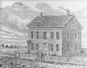
|---|---|
| Description: | Drawing of the Solomon Juneau house on East Michigan. There are tethered bears on either side of the front door. Two people are leaning on the fence, watch... |

| Date: | 1836 |
|---|---|
| Description: | A series of ink, watercolor, and pencil on paper, hand-drawn maps of the townships of Darlington and Gratiot in Lafayette County, Wisconsin, showing the to... |

| Date: | 1836 |
|---|---|
| Description: | This early to mid-19th century map shows the township and range system, sections, landownership, furnaces, lead mines, copper mines, and roads in the vicin... |

| Date: | 1836 |
|---|---|
| Description: | This map shows settlers houses and businesses, trails, and swamps. The relief is shown by hachures. The map includes illustrations of historical buildings ... |

| Date: | 1836 |
|---|---|
| Description: | This map is pen-and-ink on paper and shows marshlands, rivers, creeks, a quarry, and a few roads. |

| Date: | 1836 |
|---|---|
| Description: | This map of Belmont includes notarization from the justice of the peace of Iowa County, May 15, 1836, acknowledging John Atchison as proprietor of Belmont ... |

| Date: | 1836 |
|---|---|
| Description: | This is a cadastral map and shows proposed lot and block numbers for a paper city on the banks of the Rock River. Also shown are two public squares and som... |

| Date: | 1836 |
|---|---|
| Description: | This map is ink on tracing paper and shows block numbers, streets, lot numbers of block no. 6, and a public square in Newburgh, a paper city (a city planne... |

| Date: | 1836 |
|---|---|
| Description: | This negative photostat map shows the "oak tree, place of beginning" on the division line between Stockbridge and Brothertown Indians, and Governor Porter'... |
If you didn't find the material you searched for, our Library Reference Staff can help.
Call our reference desk at 608-264-6535 or email us at: