| Date: | 1836 |
|---|---|
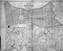
| Description: | Map of all Dane County and eastern towns. |

| Date: | 1836 |
|---|---|
| Description: | The top map is the "Plat of Madison the Capitol of Wisconsin." The bottom map is the "Map of the Four Lake Country. Taken from the Township Maps in the U.S... |

| Date: | 1836 |
|---|---|
| Description: | Map shows rivers, creeks, roads, trails, mills, and town of Madison. Includes significant manuscript annotations; Sheet 1 is watercolor on lithographed map... |

| Date: | 1836 |
|---|---|
| Description: | This map show plat of the city, local streets, block numbers, section lines, and canals. The map includes reference text: "Surveyor's office, Brown County ... |
If you didn't find the material you searched for, our Library Reference Staff can help.
Call our reference desk at 608-264-6535 or email us at: