 Filter: Categories of Wisconsin Historical Images
Filter: FULL_DATE of 1836
Filter: Community of Milwaukee
Filter: Categories of Wisconsin Historical Images
Filter: FULL_DATE of 1836
Filter: Community of Milwaukee
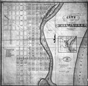
| Date: | 1836 |
|---|---|
| Description: | Map of Milwaukee including the Milwaukee River and Lake Michigan shore. |
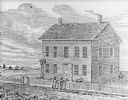
| Date: | 1836 |
|---|---|
| Description: | Drawing of the Solomon Juneau house on East Michigan. There are tethered bears on either side of the front door. Two people are leaning on the fence, watch... |

| Date: | 1836 |
|---|---|
| Description: | This hand-colored manuscript map shows the township and section grid in southeastern Wisconsin, covering the area west to Sugar River and Four Lakes region... |

| Date: | 1836 |
|---|---|
| Description: | Pencil on tracing paper. Rough sketch of Milwaukee. Left top corner reads: "From Map of northern part of Illinois and the surveyed part of Wisconsin Territ... |

| Date: | 1836 |
|---|---|
| Description: | This map shows settlers houses and businesses, trails, and swamps. The relief is shown by hachures. The map includes illustrations of historical buildings ... |
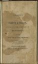
| Date: | 1836 |
|---|---|
| Description: | Title page of Increase Lapham's A catalog of Plants & Shells, Found in the vicinity of Milwaukee on the West Side of Lake Michigan, |
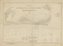
| Date: | 1836 |
|---|---|
| Description: | This map is oriented with the north to the lower right. Lake Michigan, the Menomonie River, and the Milwaukee River are labeled. Depths are shown by isolin... |
If you didn't find the material you searched for, our Library Reference Staff can help.
Call our reference desk at 608-264-6535 or email us at: