 Filter: Categories of Wisconsin Historical Images
Filter: FULL_DATE of 1837
Filter: Year of 1800-1899
Filter: Categories of Wisconsin Historical Images
Filter: FULL_DATE of 1837
Filter: Year of 1800-1899

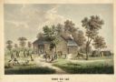
| Date: | 1837 |
|---|---|
| Description: | Fond du Lac Company House, built in 1836 and operated as an inn by Colwert Pier and his wife. Groups of Indians are in the yard outside the inn, and severa... |
| Date: | 1837 |
|---|---|
| Description: | Fond du Lac Company House. Groups of Indians are in the yard outside the inn, and several Indian dwellings are erected next to it. A man on horseback with ... |

| Date: | 1837 |
|---|---|
| Description: | Image of a runaway slave with stick and satchel. |

| Date: | 1837 |
|---|---|
| Description: | Photographic print of an amateur painting, probably representing the "first house in Madison, Wisconsin." The Peck Cabin, one of the many free variations o... |

| Date: | 1837 |
|---|---|
| Description: | Copy of N.F. Hyer's original map of Aztalan as published in the Milwaukee Advertiser, February 25, 1837. |

| Date: | 1837 |
|---|---|
| Description: | Map of the proposed route of the Milwaukee and Rock River Canal. |

| Date: | 1837 |
|---|---|
| Description: | Stereograph of Ta-vah-puts, Chief of the U-in-tah Utes, standing in a field. |

| Date: | 1837 |
|---|---|
| Description: | This map shows the townships, roads, trails, natural land forms, vegetation, mill sites and lead and copper deposits in the Wisconsin Territory at the time... |

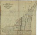
| Date: | 1837 |
|---|---|
| Description: | Map of Lake Winnebago and the area south of the Fox River from Green Bay to Sheboygan. The map is oriented with North to the right. |
| Date: | 1837 |
|---|---|
| Description: | This map shows the townships, counties, prairies, and swamps in the Wisconsin Territory at the time. It includes the land south of the Wisconsin and Fox Ri... |

| Date: | 1837 |
|---|---|
| Description: | A pen and ink on tracing paper, hand-drawn and colored map the proposed route of the Milwaukee and Rock River Canal, ranging from the Rock River in the wes... |

| Date: | 1837 |
|---|---|
| Description: | This manuscript map, copied in 1837 from a map in the Green Bay Land Office, Navarino, shows sections, the Shebowegan Trail, sandstone ledges, rivers, stre... |

| Date: | 1837 |
|---|---|
| Description: | This map shows the planned military posts/depots, roads, existing forts, rivers, and land assigned to various Indian tribes. Illinois, Mississippi, Arkansa... |

| Date: | 1837 |
|---|---|
| Description: | This map shows planned military posts/depots, barracks, rivers, lakes, roads, existing forts, and land assigned to various Indian tribes. Arkansas, Illinoi... |

| Date: | 1837 |
|---|---|
| Description: | This map shows the proposed Rock River Canal, between Milwaukee County thru the west line of what is now Waukesha County. Also shows townships, roads, hydr... |

| Date: | 1837 |
|---|---|
| Description: | Hollow-cut silhouette of Lydia C. Sawyer, who died Feb. 11, 1837 at age 22. Portrait faces right (proper left), with hair up, and a fringed collar. |
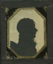
| Date: | 1837 |
|---|---|
| Description: | Aperture-type silhouette cut from ivory colored paper on black ground of unidentified man. Subject faces right (proper left) wearing a tie and ruffled shir... |
If you didn't find the material you searched for, our Library Reference Staff can help.
Call our reference desk at 608-264-6535 or email us at: