 Filter: Categories of Wisconsin Historical Images
Filter: FULL_DATE of 1846
Filter: Categories of Wisconsin Historical Images
Filter: FULL_DATE of 1846
| Date: | 1846 |
|---|---|
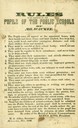
| Description: | "Rules to be observed by the pupils of public schools of Milwaukee." |
| Date: | 1846 |
|---|---|
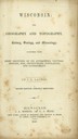
| Description: | Title page of the book "Wisconsin: Geography and Topography". |
| Date: | 1846 |
|---|---|
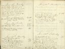
| Description: | Two pages of Samuel Marshall's 1846 diary, filled with daily entries. |
| Date: | 1846 |
|---|---|
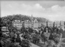
| Description: | A view of the college and surrounding green space at Saint Clara Academy. Saint Clara Academy moved to River Forest, Illinois in 1922, and since 1970 has g... |

| Date: | 1846 |
|---|---|
| Description: | A hand-colored map of Wisconsin shows the counties in the state south and east of the Wisconsin and Fox rivers and the locations of Indian lands to the nor... |

| Date: | 1846 |
|---|---|
| Description: | Drawn two years before Wisconsin entered statehood, this map shows the counties and towns that existed at the time, as well as known rivers and lakes. By 1... |

| Date: | 1846 |
|---|---|
| Description: | A map of Wisconsin and a portion of Minnesota that show the township surveys in progress in portions of the Saint Croix River region and in central Wiscons... |

| Date: | 1846 |
|---|---|
| Description: | This map shows the counties and towns in existence at the time as well as lead and copper mines. |

| Date: | 1846 |
|---|---|
| Description: | This map of Prairieville, later renamed Waukesha, is ink and pencil on paper and shows the Fox River, a plat of village, and lot owners. |

| Date: | 1846 |
|---|---|
| Description: | This map is paint and ink on board with relief shown pictorially. The map was planned by Alfred Ames, drawn by one daughter and painted by another daughter... |
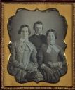
| Date: | 1846 |
|---|---|
| Description: | Sixth plate daguerreotype of Betsy H. Smith, left, with her daughter, Laura, right,and son, George. The three are the mother, sister and brother of Rosella... |

| Date: | 1846 |
|---|---|
| Description: | This plat map, which features the very early spelling of Wisconsin as "Wiskonsin", was created sometime between 1846 and 1854 and shows a canal and dam on ... |

| Date: | 1846 |
|---|---|
| Description: | This map shows lot and block numbers, roads, railroads, and some landowners’ names and includes the manuscript annotations: "From the Lapham collection" --... |

| Date: | 1846 |
|---|---|
| Description: | This map shows lot and block numbers, local streets, railroads, some landowners’ names, Milwaukee River, Menomonee River, and part of Lake Michigan. The ma... |

| Date: | 1846 |
|---|---|
| Description: | This map shows rivers, lakes, and towns in states west of the Mississippi River. Lake Michigan, Lake Superior, and Green Bay are labeled. Some areas are ou... |

| Date: | 1846 |
|---|---|
| Description: | This map shows the plotting of the various townships in Wisconsin, both those that had been surveyed and some outlines for those which have not. A note in ... |

| Date: | 1846 |
|---|---|
| Description: | Sixth plate daguerreotype of Jacob Porter Norton (1793-1846). Quarter-length portrait, facing slightly right. Norton is wearing a suit, bow tie, and stand ... |
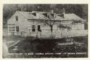
| Date: | 1846 |
|---|---|
| Description: | A wooden building enclosed by a fence. Caption on rear of photograph reads: First Church In Sauk-Prairie-Roxbury Region - 1846. Reproduction of an early ph... |

| Date: | 1846 |
|---|---|
| Description: | Chart of Green Bay showing depths and locations of numerous islands at a scale of 1 inch to 2 miles. There is also a profile of the dividing ridge at Sturg... |

| Date: | 1846 |
|---|---|
| Description: | Three-quarter length portrait of David Agry, member of the Wisconsin State Assembly from the Brown County district, 1848-1849. He was a lawyer, jurist, and... |
If you didn't find the material you searched for, our Library Reference Staff can help.
Call our reference desk at 608-264-6535 or email us at: