 Filter: Categories of Wisconsin Historical Images
Filter: FULL_DATE of 1848
Filter: Subject of land
Filter: Subject of lakes
Filter: Categories of Wisconsin Historical Images
Filter: FULL_DATE of 1848
Filter: Subject of land
Filter: Subject of lakes

| Date: | 1848 |
|---|---|
| Description: | In 1849, northern Wisconsin was composed of huge sectional regions such as Chippewa, Portage, Brown and Crawford, whereas southern Wisconsin was constitute... |

| Date: | 1848 |
|---|---|
| Description: | Immigrant map. |

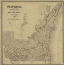
| Date: | 1848 |
|---|---|
| Description: | Wisconsin became the thirtieth state in 1848. Drawn that same year, this map shows township lines, roads, villages, mills, railroads, prairies, swamps, can... |

| Date: | 1848 |
|---|---|
| Description: | This map by Increase Lapham shows the township and range system in southern and eastern Wisconsin as well as along the Wisconsin River in present-day Marat... |
| Date: | 1848 |
|---|---|
| Description: | This map shows the township and range system in southern and eastern Wisconsin as well as along the Wisconsin River in present-day Marathon, Portage, and W... |
If you didn't find the material you searched for, our Library Reference Staff can help.
Call our reference desk at 608-264-6535 or email us at: