 Filter: Categories of Wisconsin Historical Images
Filter: FULL_DATE of 1849
Filter: Subject of water
Filter: Subject of transportation
Filter: Categories of Wisconsin Historical Images
Filter: FULL_DATE of 1849
Filter: Subject of water
Filter: Subject of transportation

| Date: | 1849 |
|---|---|
| Description: | Pencil sketch of a cross-section of the Dells of the Wisconsin River. People are in a row boat in the center. Caption at bottom: "The Dells — Wisconsin Riv... |

| Date: | 1849 |
|---|---|
| Description: | A hand-drawn map of showing the two proposed routes from the Milwaukee River to the Moody’s Lime Quarry at Milwaukee, Wisconsin. The map includes the route... |
| Date: | 1849 |
|---|---|
| Description: | The map reads: "Dartford is centrally located in Wisconsin, on the north side of Green Lake, and in full view of that beautiful sheet of Water. Its precise... |

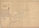
| Date: | 1849 |
|---|---|
| Description: | This map shows lot and block numbers, wards, local streets, railroads, some landowners’ names, Milwaukee River, Menomonee River, and part of Lake Michigan.... |

| Date: | 1849 |
|---|---|
| Description: | This map shows lot and block numbers, wards, local streets, railroads, some landowners’ names, Milwaukee River, Menomonee River, and part of Lake Michigan.... |

| Date: | 1849 |
|---|---|
| Description: | Version of the Wisconsin Seal found in The American's Own Book, 1849. It depicts a plow and a bundle of wheat in the foreground, and a steamship on ... |
If you didn't find the material you searched for, our Library Reference Staff can help.
Call our reference desk at 608-264-6535 or email us at: