 Filter: Categories of Wisconsin Historical Images
Filter: FULL_DATE of 1850
Filter: Subject of streets
Filter: Categories of Wisconsin Historical Images
Filter: FULL_DATE of 1850
Filter: Subject of streets

| Date: | 1850 |
|---|---|
| Description: | Bird's-eye view of business district of Oshkosh, "drawn after nature" by the artist. |

| Date: | 1850 |
|---|---|
| Description: | Ink on paper. Shows local streets and Pekatonika River. "John M. Keep, proprietor. "Original plat of Darlington as surveyed by Richardson on June 14, 1850.... |

| Date: | 1850 |
|---|---|
| Description: | This map of Cassville shows plat of town, roads, and the Mississippi River. Relief is shown by hachures. The map includes an inset map of a Plat of townshi... |

| Date: | 1850 |
|---|---|
| Description: | This map of Geneva shows lots and acreages, reserved land, and public squares. Streets and Lake Geneva are labeled. The map includes manuscript annotations... |
| Date: | 1850 |
|---|---|
| Description: | This map shows a plat of city, land ownership by name, local streets, roads, and part of Willow River and Lake St. Croix. The map is indexed by additions a... |

| Date: | 1850 |
|---|---|
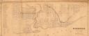
| Description: | This map shows a plat of the town, land owners by name, local streets, railroads, churches, and part of the Rock River. The map is also indexed by church d... |

| Date: | 1850 |
|---|---|
| Description: | This photocopied map shows lot and block numbers, selected buildings, street names and state lock located on the Fox River. Includes a description of Deper... |
If you didn't find the material you searched for, our Library Reference Staff can help.
Call our reference desk at 608-264-6535 or email us at: