 Filter: Categories of Wisconsin Historical Images
Filter: FULL_DATE of 1852
Filter: Subject of transportation
Filter: Subject of roads
Filter: Categories of Wisconsin Historical Images
Filter: FULL_DATE of 1852
Filter: Subject of transportation
Filter: Subject of roads

| Date: | 1852 |
|---|---|
| Description: | Pencil drawing of Madison landscape as seen from University Hill. The main street in the center is State Street, and the building with Greek columns in the... |

| Date: | 1852 |
|---|---|
| Description: | Pencil drawing of view overlooking Madison. The sketch looks down North Hamilton Street from the capitol. Rutted, irregular streets and frame houses mark ... |

| Date: | 1852 |
|---|---|
| Description: | Map reads: "The State of Wisconsin- compiled from the latest authorities". In addition, there is a scale which is six miles for every inch, and a profile o... |

| Date: | 1852 |
|---|---|
| Description: | Map created between 1852 and 1867 shows numbered lots, labelled roads, the "Centre Line of LaCrosse & Milwaukee R.R." railroad, and a station house. Roads ... |

| Date: | 1852 |
|---|---|
| Description: | This map shows plat of three towns, sections, local streets, the Grand Chute Island, and part of the Fox River. The map includes 1 inset map: "Diagram of C... |
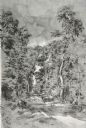
| Date: | 1852 |
|---|---|
| Description: | View down a road lined with trees. Two people in a horse-drawn vehicle are moving down the road. Caption reads: "Unidientified road in the vicinity of Madi... |
If you didn't find the material you searched for, our Library Reference Staff can help.
Call our reference desk at 608-264-6535 or email us at: