 Filter: Categories of Wisconsin Historical Images
Filter: FULL_DATE of 1863
Filter: Subject of rivers
Filter: Categories of Wisconsin Historical Images
Filter: FULL_DATE of 1863
Filter: Subject of rivers
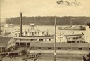
| Date: | 1863 |
|---|---|
| Description: | Elevated view of the steamboat Golden Era, which did service during the Civil War, docked near buildings. It was sold to Michael Purcell of New Orle... |
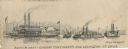
| Date: | 1863 |
|---|---|
| Description: | Four boats shown. One is a repair boat and the other two the gunboats "Cincinnatti" [sic] and "Lexington." There is a steamboat marked "Marie Denin"... |

| Date: | 1863 |
|---|---|
| Description: | A map of Illinois showing all railroads, stations, and towns. |

| Date: | 1863 |
|---|---|
| Description: | This map shows roads, railroads, settlements, farms with owners' names, vegetation, streams, and fords in Culpeper County region during the Civil War. A ma... |

| Date: | 1863 |
|---|---|
| Description: | This map illustrates the position of Fort Hindman at Arkansas Post on the Arkansas River. Depicted are the positions of Confederate defenses as well ships ... |

| Date: | 1863 |
|---|---|
| Description: | A general map of the southeastern United States showing Missouri, Kentucky, West Virginia, Virginia, North Carolina, South Carolina, Georgia, Florida, Alab... |

| Date: | 1863 |
|---|---|
| Description: | Includes index to public buildings, churches, schools. Inset: Glidden & Lockwood’s addition. Gives names of some property owners. |
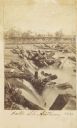
| Date: | 1863 |
|---|---|
| Description: | Carte-de-visite view of the Falls of Saint Anthony and logs caught on rocks in the falls. |
If you didn't find the material you searched for, our Library Reference Staff can help.
Call our reference desk at 608-264-6535 or email us at: