 Filter: Categories of Wisconsin Historical Images
Filter: FULL_DATE of 1863
Filter: Subject of transportation
Filter: Categories of Wisconsin Historical Images
Filter: FULL_DATE of 1863
Filter: Subject of transportation
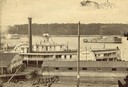
| Date: | 1863 |
|---|---|
| Description: | Elevated view of the steamboat Golden Era, which did service during the Civil War, docked near buildings. It was sold to Michael Purcell of New Orle... |
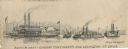
| Date: | 1863 |
|---|---|
| Description: | Four boats shown. One is a repair boat and the other two the gunboats "Cincinnatti" [sic] and "Lexington." There is a steamboat marked "Marie Denin"... |
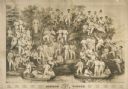
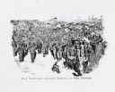
| Date: | 1863 |
|---|---|
| Description: | Black & white lithograph by Milwaukee lithographer Louis Kurz depicting the Madison Turners or Turnverein at a shooting party on the Madison lakefront. Th... |

| Date: | 1863 |
|---|---|
| Description: | View across street towards Senator Philetus Sawyer's residence. Sawyer was elected to the U.S. Senate in 1881. People are posing in horse-drawn vehicles in... |
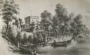
| Date: | 1863 |
|---|---|
| Description: | View of the shoreline on the Walker Castle grounds. Two men are boating while a young boy fishes from the shore. |
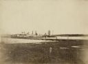
| Date: | 1863 |
|---|---|
| Description: | View from shoreline of the side-wheel steamship "Thomas Powell," probably in southern waters. Industrial buildings are in the background. |
| Date: | 1863 |
|---|---|
| Description: | Woodcut of Andersonville Prison from the "Report of the Andersonville Monument Commission." About 1863-1865. |

| Date: | 1863 |
|---|---|
| Description: | A map of Illinois showing all railroads, stations, and towns. |

| Date: | 1863 |
|---|---|
| Description: | This map is a hand-colored, pen and ink, drawing by Ole R. Dahl of Co. B, 15 Wisconsin Infantry shows the battlefield at Stones River, depicting roads, str... |

| Date: | 1863 |
|---|---|
| Description: | These detailed topographical maps of the Battle of Gettysburg show drainage, vegetation, roads, railroads, fences, houses with names of residents, and a de... |

| Date: | 1863 |
|---|---|
| Description: | These detailed topographical maps of the Battle of Gettysburg show drainage, vegetation, roads, railroads, fences, houses with names of residents, and a de... |

| Date: | 1863 |
|---|---|
| Description: | These detailed topographical maps of the Battle of Gettysburg show drainage, vegetation, roads, railroads, fences, houses with names of residents, and a de... |

| Date: | 1863 |
|---|---|
| Description: | This colored map of the Battle of Chattanooga depicts the positions of the Union and Confederate troops before the battle and on each day of the battle. Al... |

| Date: | 1863 |
|---|---|
| Description: | This map shows drainage, vegetation, roads, railroads, fences, dwellings with names of inhabitants, and land owned by the United States. Union and Confeder... |

| Date: | 1863 |
|---|---|
| Description: | This map of the Battle of Chattanooga depicts roads, railroads, drainage, vegetation, relief, and the names of residents in the outlying areas. Fourteen Wi... |
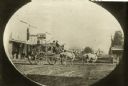
| Date: | 1863 |
|---|---|
| Description: | Photographic postcard of a stagecoach pulled by four horses in the road in front of a harness shop. Two men sit in the upper seat. A handful of people stan... |
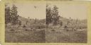
| Date: | 1863 |
|---|---|
| Description: | Stereograph of a scene near the site of the Gettysburg battlefield. Two men sit in a wagon in the center of the image. |

| Date: | 1863 |
|---|---|
| Description: | Includes index to public buildings, churches, schools. Inset: Glidden & Lockwood’s addition. Gives names of some property owners. |

| Date: | 1863 |
|---|---|
| Description: | This map of Superior shows Montgomery's Addition. An inset map shows the south west end of Lake Superior where Montgomery's Addition is located. The map re... |
| Date: | 1863 |
|---|---|
| Description: | This plat map of Brillion is ink and pencil on paper. The front of the map shows a plat of the town, roads, and Spring Creek, and includes a significant ha... |
If you didn't find the material you searched for, our Library Reference Staff can help.
Call our reference desk at 608-264-6535 or email us at: