 Filter: Categories of Wisconsin Historical Images
Filter: FULL_DATE of 1864
Filter: Subject of hills
Filter: Categories of Wisconsin Historical Images
Filter: FULL_DATE of 1864
Filter: Subject of hills
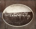
| Date: | 1864 |
|---|---|
| Description: | Oval-framed view of the village, founded by Delos W. Taft, had its name changed to Bloomington in 1867. It had been named Tafton. |
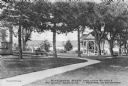
| Date: | 1864 |
|---|---|
| Description: | View across lawn toward a gazebo, section of a porch, and benches on the campus of St. Mary Academy. The lawn overlooks the Iowa Bluffs across the Mississi... |

| Date: | 1864 |
|---|---|
| Description: | This map is pen and watercolor on paper and shows profile and geological formation of Blue Mound and location of Arnold’s Hotel and Brigham Lead Mines. |

| Date: | 1864 |
|---|---|
| Description: | This map is pen and watercolor on paper and shows a profile and geological sections of the Blue Mounds, Hollow Run, Bogies Hollow Run, Bear Creek, East Bre... |

| Date: | 1864 |
|---|---|
| Description: | This map is pen and watercolor on paper and shows a profile and geological sections of the Spensley Break, James Break, Wisconsin River, and Little Bear Cr... |

| Date: | 1864 |
|---|---|
| Description: | This map is pen and pencil on paper and shows a profile of the Blue Mound and East Blue Mound. |

| Date: | 1864 |
|---|---|
| Description: | This map is pen and watercolor on paper and shows a profile and the geological formation of Blue Mound. Also shown is the location of Arnold's Hotel and Br... |
If you didn't find the material you searched for, our Library Reference Staff can help.
Call our reference desk at 608-264-6535 or email us at: