 Filter: Categories of Wisconsin Historical Images
Filter: FULL_DATE of 1864
Filter: Subject of industries
Filter: Categories of Wisconsin Historical Images
Filter: FULL_DATE of 1864
Filter: Subject of industries
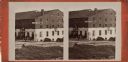
| Date: | 1864 |
|---|---|
| Description: | Stereograph of the main building, a tenement (loft style) building, at Libby Prison. |
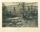
| Date: | 1864 |
|---|---|
| Description: | View from shoreline of tall trestle bridge on the railroad line crossing the river at Whiteside. Two men sit on logs in the river on the left. More men sit... |
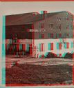
| Date: | 1864 |
|---|---|
| Description: | Stereograph of the main building, a tenement (loft style) building, at Libby Prison. |

| Date: | 1864 |
|---|---|
| Description: | This map is pen and watercolor on paper and shows profile and geological formation of Blue Mound and location of Arnold’s Hotel and Brigham Lead Mines. |
| Date: | 1864 |
|---|---|
| Description: | This document, sometimes cited as the “Statement made by the Indians, a bilingual petition of the Chippewas of Lake Superior, 1864,” was carried by an Ojib... |

| Date: | 1864 |
|---|---|
| Description: | This map is pen and watercolor on paper and shows a profile and the geological formation of Blue Mound. Also shown is the location of Arnold's Hotel and Br... |

| Date: | 1864 |
|---|---|
| Description: | This map shows locations of quarries, sink holes, creeks, springs, rivers, houses, forts, and roads. Annotations in pencil read: "Is the top of the mound l... |

| Date: | 1864 |
|---|---|
| Description: | This map shows locations of quarries, sink holes, creeks, springs, rivers, houses, forts, and roads. The upper right corner and right margin includes anno... |

| Date: | 1864 |
|---|---|
| Description: | Map showing locations of quarries, sink holes, creeks, springs, rivers, houses, forts, and roads. The map appears to have been drawn on to of a plat map of... |

| Date: | 1864 |
|---|---|
| Description: | This map shows locations of quarries, sink holes, creeks, springs, rivers, houses, forts, and roads. |
If you didn't find the material you searched for, our Library Reference Staff can help.
Call our reference desk at 608-264-6535 or email us at: