Filter: Categories of Wisconsin Historical Images
Filter: FULL_DATE of 1865
Filter: Subject of water
Filter: Categories of Wisconsin Historical Images
Filter: FULL_DATE of 1865
Filter: Subject of water

| Date: | 1865 |
|---|---|
| Description: | A woodprint of women with frightened child entitled "The First Dip Into Salt Water." |
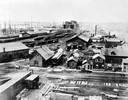
| Date: | 1865 |
|---|---|
| Description: | Elevated view of the first Milwaukee railroad depot, which was used by the Milwaukee & Waukesha and the Milwaukee & Mississippi railroads. The Milwaukee &... |
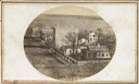
| Date: | 1865 |
|---|---|
| Description: | South Wisconsin Avenue and West Main Street. Lake Monona is in the background and the Lucius Fairchild and David Atwood houses are at the upper left. The r... |
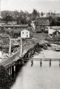
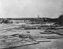
| Date: | 1865 |
|---|---|
| Description: | Elevated view of a bridge and logging debris around residential homes. |

| Date: | 1865 |
|---|---|
| Description: | Milwaukee Street looking west. In the foreground is a dog standing on a bridge. Signs on a building on the right read: "Furniture" and "Valley Chief Reaper... |

| Date: | 1865 |
|---|---|
| Description: | Elevated view of Milwaukee Street. |

| Date: | 1865 |
|---|---|
| Description: | Zeeland Mills, built in 1862 by John Verstegen. The flour mill was 36' x 50', four stories and had "two runs of stone." It was still operating in 1911. |

| Date: | 1865 |
|---|---|
| Description: | Map showing the location of meteorological stations and effects that Lake Michigan has had on Wisconsin temperatures in January and July. The map shows cou... |

| Date: | 1865 |
|---|---|
| Description: | Exterior of Fort Sumpter [sic]. There are several men and a boat on the shoreline in the foreground. Plate 56 |

| Date: | 1865 |
|---|---|
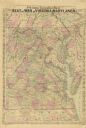
| Description: | This map of Maryland and Virginia shows railroads, rivers, cities and towns, and the positions of Confederate troops and defenses in Virginia in 1861. |

| Date: | 1865 |
|---|---|
| Description: | This map is a pen and ink tracing. Union positions are shown in blue and Confederate positions are shown in red. Roads, vegetation, and streams are labeled... |
| Date: | 1865 |
|---|---|
| Description: | A general map of eastern Virginia, Maryland, Delaware, southern Pennsylvania, and northern North Carolina. |

| Date: | 1865 |
|---|---|
| Description: | This pen and ink map sketches the route taken by General Sherman's troops from Atlanta, Georgia, to Savannah, Georgia. Railroads, rivers, and towns are lab... |

| Date: | 1865 |
|---|---|
| Description: | This map of the Bentonville, N.C., battlefield illustrates the positions of the Union and the Confederate troops, roads, rivers, vegetation, and the names ... |

| Date: | 1865 |
|---|---|
| Description: | This map shows county boundaries, outlined in red. Each county's population is handwritten in the margins. The map also includes towns, rivers and lakes. |

| Date: | 1865 |
|---|---|
| Description: | This map shows the population density per square mile in the entire state, showing southeastern and southern Wisconsin had the greatest population density ... |

| Date: | 1865 |
|---|---|
| Description: | Drawn the last year of the Civil War, this thematic map shows the effects that Lake Michigan has had on Wisconsin temperatures in January and July. The map... |

| Date: | 1865 |
|---|---|
| Description: | This map of the entire state of Wisconsin depicts the township survey grid and identifies counties, named towns, cities and villages, rivers, lakes, railro... |

| Date: | 1865 |
|---|---|
| Description: | This map shows the river shore and piers. Lake Michigan is labeled. Depths are shown by soundings and isolines. The bottom margin includes notes on soundi... |
If you didn't find the material you searched for, our Library Reference Staff can help.
Call our reference desk at 608-264-6535 or email us at: