 Filter: Categories of Wisconsin Historical Images
Filter: FULL_DATE of 1871
Filter: Type of Map or Atlas
Filter: Creator Name of Unknown
Filter: Categories of Wisconsin Historical Images
Filter: FULL_DATE of 1871
Filter: Type of Map or Atlas
Filter: Creator Name of Unknown
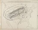
| Date: | 1871 |
|---|---|
| Description: | Weather map depicting the great cyclonic storm that prevailed the day of the Peshtigo and Chicago fires. |

| Date: | 1871 |
|---|---|
| Description: | The township grid in the counties bordering Lake Superior in northern Wisconsin and Minnesota is shown. Rivers, lakes, Indian reservations, and the rail li... |

| Date: | 1871 |
|---|---|
| Description: | Map created between 1871 and 1880. Shows townships, post offices, a possible railroad to Penoka Iron Range, and the North Wisconsin Railroad. |

| Date: | 1871 |
|---|---|
| Description: | A map of California showing railroad lines and reservations. |
If you didn't find the material you searched for, our Library Reference Staff can help.
Call our reference desk at 608-264-6535 or email us at: