Filter: Categories of Wisconsin Historical Images
Filter: FULL_DATE of 1871
Filter: Subject of transportation
Filter: Creator Name of Unknown
Filter: Categories of Wisconsin Historical Images
Filter: FULL_DATE of 1871
Filter: Subject of transportation
Filter: Creator Name of Unknown
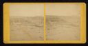
| Date: | 1871 |
|---|---|
| Description: | Street scene showing destruction after Peshtigo fire. |
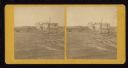
| Date: | 1871 |
|---|---|
| Description: | Fire destruction near railroad tracks after Peshtigo fire. There are wheel carriages from destroyed boxcars on and near the tracks. |

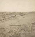
| Date: | 1871 |
|---|---|
| Description: | Elevated view of South Twelfth Street. There is a child standing in the center of the street holding onto a wagon in which another child is sitting. A chur... |
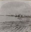
| Date: | 1871 |
|---|---|
| Description: | Stereograph of a sawmill area and Lake Winnebago in the foreground. The square building with the "cupola" was the Revere House. A manuscript notation, very... |

| Date: | 1871 |
|---|---|
| Description: | Stereograph. In the right background is the building of the Trade Reporter newspaper at the corner of Main and High Streets; across the street from it is J... |
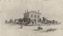
| Date: | 1871 |
|---|---|
| Description: | The building has a fence around it and the yard is filled with trees. Pedestrians are in the road, as well as a man riding a horse. |

| Date: | 1871 |
|---|---|
| Description: | Stereograph. In the right background is the building of the Trade Reporter newspaper at the corner of Main and High Streets; across the street from it is J... |

| Date: | 1871 |
|---|---|
| Description: | The township grid in the counties bordering Lake Superior in northern Wisconsin and Minnesota is shown. Rivers, lakes, Indian reservations, and the rail li... |

| Date: | 1871 |
|---|---|
| Description: | Map created between 1871 and 1880. Shows townships, post offices, a possible railroad to Penoka Iron Range, and the North Wisconsin Railroad. |

| Date: | 1871 |
|---|---|
| Description: | A map of California showing railroad lines and reservations. |
If you didn't find the material you searched for, our Library Reference Staff can help.
Call our reference desk at 608-264-6535 or email us at: