Filter: Categories of Wisconsin Historical Images
Filter: FULL_DATE of 1873
Filter: Subject of human settlements
Filter: Subject of land
Filter: Categories of Wisconsin Historical Images
Filter: FULL_DATE of 1873
Filter: Subject of human settlements
Filter: Subject of land

| Date: | 1873 |
|---|---|
| Description: | Main Street, with its dirt, ruts, cows (and presumably manure), but wide enough for easy hitching of wagons and teams. |
| Date: | 1873 |
|---|---|
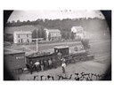
| Description: | Elevated view of several men, some of whom may be railroad workers, posing in front of a Minnesota and St. Paul wood-burning engine at a train crossing. Th... |

| Date: | 1873 |
|---|---|
| Description: | Map of the township of Windsor, from the "Atlas of Dane County." |

| Date: | 1873 |
|---|---|
| Description: | View, ca. 1873-1879, of Madison looking down Wisconsin Avenue toward the third Wisconsin Capitol, a view that suggests something of the ongoing importance ... |
| Date: | 1873 |
|---|---|
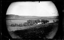
| Description: | View across field towards the Amund Rustebakke farm. Twelve haystacks dominate the left and center of the image, and two people are standing on top of the ... |

| Date: | 1873 |
|---|---|
| Description: | Color outline map of Dane County, Wisconsin. |
| Date: | 1873 |
|---|---|
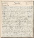
| Description: | A map of Verona Township from the Dane County Atlas. |

| Date: | 1873 |
|---|---|
| Description: | A hand-colored, geological map of the Fox and Wisconsin rivers’ water path from the Mississippi River to the Great Lakes. The map also shows those railroad... |

| Date: | 1873 |
|---|---|
| Description: | Map of Wisconsin showing counties, county seats, cities with populations over 3,000, and congressional districts. The map also includes rivers, lakes, rail... |

| Date: | 1873 |
|---|---|
| Description: | This hand-colored map of Wisconsin shows the township grid, railroads and proposed railroads, counties, cities, villages, and post offices. Population tabl... |
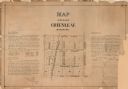
| Date: | 1873 |
|---|---|
| Description: | A plat of the village of Greenleaf, Brown County, Wisconsin, showing the areas from Taintor Street to Day Street and Follett Street to Deuster Street. Inc... |

| Date: | 1873 |
|---|---|
| Description: | A map that covers parts of Winona and Houston Counties, Minnesota and La Crosse County, Wisconsin, showing the proposed railroad routes, constructed rail l... |
| Date: | 1873 |
|---|---|
| Description: | This 1873 map shows Clark County, Wisconsin, as well as the portion of Taylor County that was then part of Clark. The township and range grid, sections, ra... |

| Date: | 1873 |
|---|---|
| Description: | This late 19th century map shows the lake region around Oconomowoc in Waukesha County and eastern Jefferson County, Wisconsin. The township and range grid,... |

| Date: | 1873 |
|---|---|
| Description: | This 1873 map of Chippewa County, Wisconsin, which at the time also encompassed all or part of Price, Rusk, Sawyer, and Taylor counties, shows the township... |

| Date: | 1873 |
|---|---|
| Description: | This map shows lots and blocks, additions and subdivisions, and large-scale landownership. The map is oriented with north to the upper right. The map is fr... |

| Date: | 1873 |
|---|---|
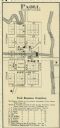
| Description: | Plat map of the township of Eagle (T5N, R17E) at a scale of 2 inches to one mile. |

| Date: | 1873 |
|---|---|
| Description: | A map of the township of Primrose from the "Atlas of Dane County." |
If you didn't find the material you searched for, our Library Reference Staff can help.
Call our reference desk at 608-264-6535 or email us at: