 Filter: Categories of Wisconsin Historical Images
Filter: FULL_DATE of 1876
Filter: Community of Milwaukee
Filter: Subject of michigan, lake
Filter: Categories of Wisconsin Historical Images
Filter: FULL_DATE of 1876
Filter: Community of Milwaukee
Filter: Subject of michigan, lake

| Date: | 1876 |
|---|---|
| Description: | Made from U.S. Surveys and from minutes furnished by Jos. S. Buck and Dr. C. Chase. Scale 20 CHs to an inch. |
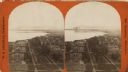
| Date: | 1876 |
|---|---|
| Description: | Stereograph. Elevated view looking roughly south, the foreground overlooks a residential neighborhood. On the far shoreline, smoke clouds spew out from lar... |
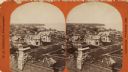
| Date: | 1876 |
|---|---|
| Description: | Stereograph of a view over rooftops of a neighborhood near Lake Michigan. Shoreline can be seen in the background. |
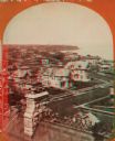
| Date: | 1876 |
|---|---|
| Description: | Stereograph of a view over rooftops of a neighborhood near Lake Michigan. Shoreline can be seen in the background. |
If you didn't find the material you searched for, our Library Reference Staff can help.
Call our reference desk at 608-264-6535 or email us at:

