 Filter: Categories of Wisconsin Historical Images
Filter: FULL_DATE of 1876
Filter: Subject of transportation
Filter: Categories of Wisconsin Historical Images
Filter: FULL_DATE of 1876
Filter: Subject of transportation

| Date: | 1876 |
|---|---|
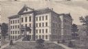
| Description: | Elevated view of building on the University of Wisconsin-Madison campus, which is located on a hill near Lake Mendota. A winding drive leads up to the hous... |
| Date: | 1876 |
|---|---|
| Description: | Engraving of the first Science Hall at University of Wisconsin-Madison. |
| Date: | 1876 |
|---|---|
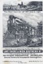
| Description: | Railroad advertising card showing a mail carrier on horseback on a plank road in 1776, and mail being delivered by train in 1876. A woman with two children... |
| Date: | 1876 |
|---|---|
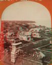
| Description: | Stereograph of a view over rooftops of a neighborhood near Lake Michigan. Shoreline can be seen in the background. |

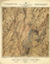
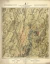
| Date: | 1876 |
|---|---|
| Description: | Detailed topographic map of the Gettysburg battlefield created thirteen years after the battle. This map shows day one of the battle. The map shows drainag... |

| Date: | 1876 |
|---|---|
| Description: | This map of the Battle of Iuka depicts the May 19, 1862, positions of the Union forces in blue and Confederate in red. Indicated on the map are roads, the ... |

| Date: | 1876 |
|---|---|
| Description: | This 1876 map of Saint Croix County, Wisconsin, shows the township and range grid, sections, towns, cities and villages, land ownership and acreages, wagon... |

| Date: | 1876 |
|---|---|
| Description: | This late 19th century map by Increase Lapham shows the lake region around Oconomowoc in Waukesha County and eastern Jefferson County, Wisconsin. Cities an... |

| Date: | 1876 |
|---|---|
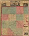
| Description: | Map shows landownership and acreages, roads and railroads, and some buildings. Includes illustrations of local buildings, business directories, and tables ... |

| Date: | 1876 |
|---|---|
| Description: | Map shows townships and sections, landownership and acreages, roads, railroads, post offices, and farms. Sections appear in pink, yellow, and blue. On the ... |
| Date: | 1876 |
|---|---|
| Description: | Map shows townships and sections, landownership and acreages, roads, railroads, and selected rural buildings. Sections are shown in green, blue, and red. T... |

| Date: | 1876 |
|---|---|
| Description: | This map is of the towns of Neenah and Menasha and shows existing and proposed canals. Water depths shown by soundings. Little Butte des Morts Lake, Doty I... |

| Date: | 1876 |
|---|---|
| Description: | A hand-colored map on six sheets, this map of Juneau County indicates the locations of townships and sections, landowners and acreages, roads, wagon roads,... |

| Date: | 1876 |
|---|---|
| Description: | This map shows existing and proposed harbor improvements, streets, the Sauk River, and Lake Michigan. On the bottom of the map inscribed in ink is: "44th C... |

| Date: | 1876 |
|---|---|
| Description: | This map is ink on tracing cloth and shows the Black River, French Slough, Little French Slough, the southern portion of North La Crosse, the Milwaukee & S... |
| Date: | 1876 |
|---|---|
| Description: | Detailed topographic map of the Gettysburg battlefield created thirteen years after the battle. This map shows day two of the battle. The map shows drainag... |
| Date: | 1876 |
|---|---|
| Description: | Detailed topographic map of the Gettysburg battlefield created thirteen years after the battle. This map shows day three of the battle. The map shows drain... |
If you didn't find the material you searched for, our Library Reference Staff can help.
Call our reference desk at 608-264-6535 or email us at:

