 Filter: Categories of Wisconsin Historical Images
Filter: FULL_DATE of 1877
Filter: Subject of business
Filter: Categories of Wisconsin Historical Images
Filter: FULL_DATE of 1877
Filter: Subject of business
| Date: | 1877 |
|---|---|
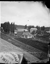
| Description: | A view from the roof across an unpaved road towards a building across the street from A.L. Dahl's photography studio. The two-story storefront is a general... |
| Date: | 1877 |
|---|---|
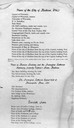
| Description: | The second page of Dahl's 1877 "Catalogue of Stereoscopic Views made and published by Andrew L. Dahl, landscape photographer, DeForest, Wis." which lists v... |

| Date: | 1877 |
|---|---|
| Description: | A map of Monroe County, Wisconsin that shows the townships and landownership and acreage wagon roads, railroads, streams, schools, and houses. Also include... |

| Date: | 1877 |
|---|---|
| Description: | This 1877 map of Trempealeau County, Wisconsin, shows the township and range grid, sections, towns, cities and villages, land ownership and acreages, roads... |

| Date: | 1877 |
|---|---|
| Description: | Shows land ownership by name, churches, schools, farm houses, wagon roads, railroads. Includes directory of businesses for Columbus, Portage, Doylestown, W... |

| Date: | 1877 |
|---|---|
| Description: | Relief shown by hachures. Shows land ownership by name, wards, railroads, mills, dams, city limits, Chippewa River, and Half Moon Lake. Includes index of m... |

| Date: | 1877 |
|---|---|
| Description: | Relief shown by hachures. Shows land ownership by name, wards, railroads, mills, dams, city limits, Chippewa River, and Half Moon Lake. Includes index of m... |
If you didn't find the material you searched for, our Library Reference Staff can help.
Call our reference desk at 608-264-6535 or email us at: