 Filter: Categories of Wisconsin Historical Images
Filter: FULL_DATE of 1877
Filter: Subject of roads
Filter: Categories of Wisconsin Historical Images
Filter: FULL_DATE of 1877
Filter: Subject of roads
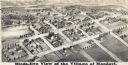
| Date: | 1877 |
|---|---|
| Description: | Bird's-eye map of Mondovi. |
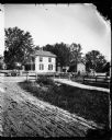
| Date: | 1877 |
|---|---|
| Description: | View of Dr. Blake's (probably Samuel M.) house in Lodi or Prairie du Sac with a white picket fence in front of it. A man is standing in the grass in front ... |
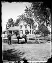
| Date: | 1877 |
|---|---|
| Description: | A dirt road leads to Dr. Blake's (probably Samuel M.) frame house in Lodi or Prairie du Sac. A family is under a tree near a wooden fence. On the right is... |
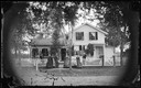
| Date: | 1877 |
|---|---|
| Description: | Family in front of picket fence and wood walkway, which encloses an upright and wing frame house with elaborate carpenter's lace and latticework on the por... |
| Date: | 1877 |
|---|---|
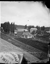
| Description: | A view from the roof across an unpaved road towards a building across the street from A.L. Dahl's photography studio. The two-story storefront is a general... |
| Date: | 1877 |
|---|---|
| Description: | Well-dressed young couples sit in the foreground. In the background is a picket fence running along a busy road with horse and buggy traffic. Further on is... |

| Date: | 1877 |
|---|---|
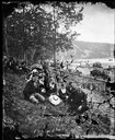
| Description: | View across road of the Eastern District Norwegian Synod, May 31-June 6, 1877, at the Immanuel Norwegian Evangelical Lutheran Church (2 1/2 miles west of L... |
| Date: | 1877 |
|---|---|
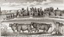
| Description: | View of cattle, sheep, and pigs in a pasture on a farm. Two houses are in the distance, and a horse-drawn carriage is moving along the road on the left. Ca... |
| Date: | 1877 |
|---|---|
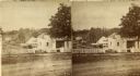
| Description: | Stereograph view of Glenn's mineral spring. |

| Date: | 1877 |
|---|---|
| Description: | A map of Monroe County, Wisconsin that shows the townships and landownership and acreage wagon roads, railroads, streams, schools, and houses. Also include... |

| Date: | 1877 |
|---|---|
| Description: | This 1877 map of Sauk County, Wisconsin, shows the township and range grid, sections, towns, cities and villages, land ownership and acreages, wagon roads,... |

| Date: | 1877 |
|---|---|
| Description: | This 1877 map of Trempealeau County, Wisconsin, shows the township and range grid, sections, towns, cities and villages, land ownership and acreages, roads... |

| Date: | 1877 |
|---|---|
| Description: | Shows land ownership by name, churches, schools, farm houses, wagon roads, railroads. Includes directory of businesses for Columbus, Portage, Doylestown, W... |

| Date: | 1877 |
|---|---|
| Description: | Two maps on one page, removed from an atlas. The first map shows Wisconsin and the upper peninsula of Michigan counties and townships while the second map ... |

| Date: | 1877 |
|---|---|
| Description: | This map shows the Fox River, Lake Winnebago, city wards, lot and block numbers, landownership, selected buildings, railroads, and roads. There are three i... |

| Date: | 1877 |
|---|---|
| Description: | This map is a photstat copy of the original and shows landownership, townships and sections, wagon roads, railroads, school houses, churches, cemeteries, m... |
If you didn't find the material you searched for, our Library Reference Staff can help.
Call our reference desk at 608-264-6535 or email us at: