 Filter: Categories of Wisconsin Historical Images
Filter: FULL_DATE of 1877
Filter: Subject of superior, lake
Filter: Categories of Wisconsin Historical Images
Filter: FULL_DATE of 1877
Filter: Subject of superior, lake
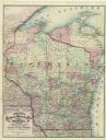
| Date: | 1877 |
|---|---|
| Description: | A hand-colored map of Wisconsin showing counties, township gridlines, river systems, and railroad routes throughout the state. The map also includes porti... |

| Date: | 1877 |
|---|---|
| Description: | Two maps on one page, removed from an atlas. The first map shows Wisconsin and the upper peninsula of Michigan counties and townships while the second map ... |
If you didn't find the material you searched for, our Library Reference Staff can help.
Call our reference desk at 608-264-6535 or email us at: