 Filter: Categories of Wisconsin Historical Images
Filter: FULL_DATE of 1881
Filter: Subject of michigan, lake
Filter: Categories of Wisconsin Historical Images
Filter: FULL_DATE of 1881
Filter: Subject of michigan, lake

| Date: | 1881 |
|---|---|
| Description: | A hand-colored map of Wisconsin that shows counties, cities, towns, villages, railroads, as well as the locations of railroad stations and post offices wit... |

| Date: | 1881 |
|---|---|
| Description: | A brochure with a map of Wisconsin that also includes information (in English, German, Norwegian, and Swedish) pertaining to the state, such as its timber ... |

| Date: | 1881 |
|---|---|
| Description: | A hand-colored, cloth mounted, sectional map of Wisconsin showing the township grid, completed and proposed railroads, counties, towns, cities, villages. T... |

| Date: | 1881 |
|---|---|
| Description: | Bird's-eye view of Milwaukee from the south lakeshore. |
| Date: | 1881 |
|---|---|
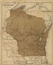
| Description: | This map shows railroads by operator and projected railroads. Eastern Minnesota, the upper peninsula of Michigan, northeastern Iowa, and northern Illinois ... |

| Date: | 1881 |
|---|---|
| Description: | This map shows railroads, county boundaries, cities, towns, and waterways with relief shown by hachures. The prime meridians are: Greenwich and Washington.... |
If you didn't find the material you searched for, our Library Reference Staff can help.
Call our reference desk at 608-264-6535 or email us at: