Filter: Categories of Wisconsin Historical Images
Filter: FULL_DATE of 1886
Filter: Subject of transportation
Filter: Categories of Wisconsin Historical Images
Filter: FULL_DATE of 1886
Filter: Subject of transportation
| Date: | 1886 |
|---|---|
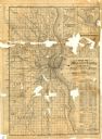
| Description: | Two maps on one page. The first page is a map of Milwaukee County with insets "Plan of Pewaukee, Waukesha Co.," "Plan of Oconomowoc, Waukesha Co.," "Plan o... |

| Date: | 1886 |
|---|---|
| Description: | Map shows townships, post offices, roads, railroads, and selected buildings. The sections are in pink, green, blue, and yellow. Counties, towns, and lakes ... |

| Date: | 1886 |
|---|---|
| Description: | This map has relief shown by hachures and includes a list of plats in order of date of record, laws which vacate plats, plats not shown as upon the county ... |
| Date: | 1886 |
|---|---|
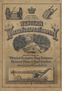
| Description: | Front cover featuring illustrations of wheeled scrapers, drag scrapers, railroad plows and road graders. |
| Date: | 1886 |
|---|---|
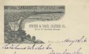
| Description: | Letterhead for the Pfister & Vogel Leather Co., with an engraving of a bird's-eye view of the city (signed Ma-- Richards, Mil Wis) advertising the "Nationa... |

| Date: | 1886 |
|---|---|
| Description: | This map shows lot and block numbers, sold lots, established dock lines, docks, slips, railroads, industrial buildings, streets, and the St. Louis Bay. |

| Date: | 1886 |
|---|---|
| Description: | This map shows north and south ore veins, landownership, railroads, rivers, and township grid in parts of Ashland County, Wis. and Ontonagon County, Mich. ... |
| Date: | 1886 |
|---|---|
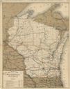
| Description: | This map shows lakes, railroads, and rivers. An explanation of railroad lines with mileage in Wisconsin and total mileage for 1886 is included. Portions o... |

| Date: | 1886 |
|---|---|
| Description: | View across water towards the George Whiting Paper Mill on the Lawson Canal. |
If you didn't find the material you searched for, our Library Reference Staff can help.
Call our reference desk at 608-264-6535 or email us at: