 Filter: Categories of Wisconsin Historical Images
Filter: FULL_DATE of 1887
Filter: Subject of cities and towns
Filter: Categories of Wisconsin Historical Images
Filter: FULL_DATE of 1887
Filter: Subject of cities and towns
| Date: | 1887 |
|---|---|
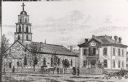
| Description: | St. Gabriel's Roman Catholic Church. Horse-drawn vehicles and pedestrians are on the street and sidewalk in front of the church. |

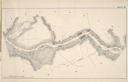
| Date: | 1887 |
|---|---|
| Description: | Benedict & Co. engineers. As shown by development to March 1st 1887. Inset: Map of northern Wisconsin showing location of range. Lands in red. |

| Date: | 1887 |
|---|---|
| Description: | View across water towards the Tonyawatha Spring Hotel on Lake Monona. The hotel, on the east shore of the lake, is located in Blooming Grove Township, just... |
| Date: | 1887 |
|---|---|
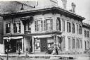
| Description: | Northwest corner of Grand Avenue and 4th Street. Built in 1854 at a cost of $18,000. The storefronts were added in 1868; the building razed in 1886. |

| Date: | 1887 |
|---|---|
| Description: | Stereograph. From the northeast (contrary to photographer's description.) A large tree stands in the center of the image along the drive, with the home be... |
| Date: | 1887 |
|---|---|
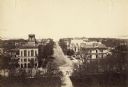
| Description: | Elevated view of Wisconsin Avenue from the Wisconsin State Capitol building. Mansions and churches are along the road, and Lake Mendota and Picnic Point ar... |
| Date: | 1887 |
|---|---|
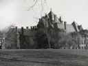
| Description: | View across Bascom Hill of Science Hall on the University of Wisconsin-Madison campus. Building built in 1887. |

| Date: | 1887 |
|---|---|
| Description: | View across Park Street towards the northwest of the new Science Hall, shortly after its completion on the University of Wisconsin-Madison campus. Part of ... |

| Date: | 1887 |
|---|---|
| Description: | Exterior of Science Hall on the University of Wisconsin-Madison campus. View from across Park Street taken shortly after completion of new building after f... |

| Date: | 1887 |
|---|---|
| Description: | View up Langdon Street of the new Science Hall on the University of Wisconsin-Madison campus. |

| Date: | 1887 |
|---|---|
| Description: | Elevated view over roof tops of lower campus looking up towards Bascom Hall. Science Hall at the end of Langdon Street is on the right side of Bascom Hill ... |
| Date: | 1887 |
|---|---|
| Description: | A map of a portion of the Mississippi River from Marais D'Osier Lake (left) to Watertown. |

| Date: | 1887 |
|---|---|
| Description: | Men on shoreline are returning logs with horses, which have been stranded on a sandbar, to the main channel of the Mississippi River. Beef Slough Company w... |
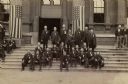
| Date: | 1887 |
|---|---|
| Description: | Group portrait outdoors of the Veterans of Company I, 29th Wisconsin Volunteer Infantry at a Grand Army of the Republic reunion. Center group, standing, fr... |
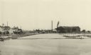
| Date: | 1887 |
|---|---|
| Description: | A view at the mouth of the Menominee River showing Ludington Wells and Van Schaick's mills. |
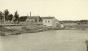
| Date: | 1887 |
|---|---|
| Description: | View of the boom company office and the site of the old trading post. |

| Date: | 1887 |
|---|---|
| Description: | The Ramsay & Jones Mill with logs in the water in the foreground. |

| Date: | 1887 |
|---|---|
| Description: | Mill workers in the yard at Ramsay & Jones Mill. |

| Date: | 1887 |
|---|---|
| Description: | A bird's-eye map of Menekaune, Menominee and Marinette. |

| Date: | 1887 |
|---|---|
| Description: | Elevated view of Marinette looking toward the mouth of the river from the tower of City Hall. Fences, fields, and industrial buildings are in the foregroun... |
If you didn't find the material you searched for, our Library Reference Staff can help.
Call our reference desk at 608-264-6535 or email us at: