 Filter: Categories of Wisconsin Historical Images
Filter: FULL_DATE of 1890
Filter: Type of Map or Atlas
Filter: Community of Milwaukee
Filter: Categories of Wisconsin Historical Images
Filter: FULL_DATE of 1890
Filter: Type of Map or Atlas
Filter: Community of Milwaukee

| Date: | 1890 |
|---|---|
| Description: | Map of Milwaukee as remembered by "Dr Enoch Chase, U.B. Smith & Others." Represented are major roads, lowlands, trails, homesteads, and lots. Map depicts t... |
| Date: | 1890 |
|---|---|
| Description: | Map of Merrill Estate property for sale and sold. Map reads: "Merrill Estate property (colored) lots marked X are sold for terms & prices inquire of S.H. C... |

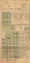
| Date: | 1890 |
|---|---|
| Description: | This map shows city wards, block numbers, parks, cemeteries, roads, railroads, and selected buildings. The map includes indexes to streets, public building... |
If you didn't find the material you searched for, our Library Reference Staff can help.
Call our reference desk at 608-264-6535 or email us at: