Filter: Categories of Wisconsin Historical Images
Filter: FULL_DATE of 1890
Filter: Type of Map or Atlas
Filter: Subject of land
Filter: Categories of Wisconsin Historical Images
Filter: FULL_DATE of 1890
Filter: Type of Map or Atlas
Filter: Subject of land

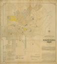
| Date: | 1890 |
|---|---|
| Description: | Bird's-eye map of Ashland, viewed from Lake Superior, with insets of Prentice Park and Fishery. Population 16,000. Increase in Ten Years, 11,000. |

| Date: | 1890 |
|---|---|
| Description: | Portion of the plat map of the north part of Caledonia in Columbia County, including explanations. |

| Date: | 1890 |
|---|---|
| Description: | Plat map of the south part of Caledonia in Columbia County. |

| Date: | 1890 |
|---|---|
| Description: | Colored bird's-eye map of Oconomowoc and the Lake Region, Waukesha County. Looking North from Government Hill. Location key below image identifies 24 Hotel... |

| Date: | 1890 |
|---|---|
| Description: | This map shows lakes, railroads, and rivers. An explanation of railroad lines with mileage in Wisconsin and total mileage for 1890 is included. Portions of... |
| Date: | 1890 |
|---|---|
| Description: | Assessors plat of the city, including the Fox River. |

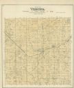
| Date: | 1890 |
|---|---|
| Description: | A plat map of a portion of Verona in Dane County. |
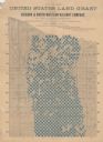
| Date: | 1890 |
|---|---|
| Description: | "For prices, terms and all particulars regarding these lands, apply to Charles E. Simmons, Land Commissioner, Chicago & North-Western Railway, Chicago, Ill... |
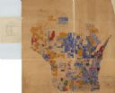
| Date: | 1890 |
|---|---|
| Description: | A hand-colored map of Wisconsin showing distribution ethnic groups based on the 1885 state census. The various nationalities are color-coded and include: I... |

| Date: | 1890 |
|---|---|
| Description: | These hand-colored maps show the sections, lakes, swamps, streams, and state, vacant, entered, and withdrawn lands in ten survey townships in Oneida, Vilas... |

| Date: | 1890 |
|---|---|
| Description: | This late 19th century map shows mining companies' lands and miscellaneous properties in the towns of Cady and Springfield in southeastern Saint Croix Coun... |

| Date: | 1890 |
|---|---|
| Description: | This map shows the Wisconsin Central Railroad land grant lands owned and for sale by the Soo Line in Ashland County, Wisconsin, as well as in portions of B... |

| Date: | 1890 |
|---|---|
| Description: | This 1890s map shows the Wisconsin Central Railroad land grant lands owned and for sale by the Soo Line in Ashland County, Wisconsin, as well as in the eas... |

| Date: | 1890 |
|---|---|
| Description: | This manuscript map of Township 16 North, Range 6 West, 4th Principal Meridian, encompasses the Town of Barre and the southern portion of the Town of Hamil... |

| Date: | 1890 |
|---|---|
| Description: | This late 19th century map shows sections, state lands, Barre Center P.O. (now Barre Mills), railroads, topography, and streams and wetlands in the Town of... |
If you didn't find the material you searched for, our Library Reference Staff can help.
Call our reference desk at 608-264-6535 or email us at: