 Filter: Categories of Wisconsin Historical Images
Filter: FULL_DATE of 1890
Filter: Type of Map or Atlas
Filter: Categories of Wisconsin Historical Images
Filter: FULL_DATE of 1890
Filter: Type of Map or Atlas
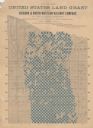
| Date: | 1890 |
|---|---|
| Description: | "For prices, terms and all particulars regarding these lands, apply to Charles E. Simmons, Land Commissioner, Chicago & North-Western Railway, Chicago, Ill... |

| Date: | 1890 |
|---|---|
| Description: | A map of Wisconsin, eastern Wisconsin and Iowa, northern Illinois, and the Upper Peninsula of Michigan. The counties, cities and villages, and rail lines i... |
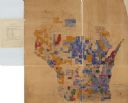
| Date: | 1890 |
|---|---|
| Description: | A hand-colored map of Wisconsin showing distribution ethnic groups based on the 1885 state census. The various nationalities are color-coded and include: I... |

| Date: | 1890 |
|---|---|
| Description: | These hand-colored maps show the sections, lakes, swamps, streams, and state, vacant, entered, and withdrawn lands in ten survey townships in Oneida, Vilas... |

| Date: | 1890 |
|---|---|
| Description: | This late 19th century map shows mining companies' lands and miscellaneous properties in the towns of Cady and Springfield in southeastern Saint Croix Coun... |

| Date: | 1890 |
|---|---|
| Description: | This map shows the Wisconsin Central Railroad land grant lands owned and for sale by the Soo Line in Ashland County, Wisconsin, as well as in portions of B... |

| Date: | 1890 |
|---|---|
| Description: | This 1890s map shows the Wisconsin Central Railroad land grant lands owned and for sale by the Soo Line in Ashland County, Wisconsin, as well as in the eas... |

| Date: | 1890 |
|---|---|
| Description: | This manuscript map of Township 16 North, Range 6 West, 4th Principal Meridian, encompasses the Town of Barre and the southern portion of the Town of Hamil... |

| Date: | 1890 |
|---|---|
| Description: | This late 19th century map shows sections, state lands, Barre Center P.O. (now Barre Mills), railroads, topography, and streams and wetlands in the Town of... |

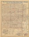
| Date: | 1890 |
|---|---|
| Description: | Shows towns of Dane County, lakes, rivers, and railroads. Relief shown by hachures. Includes color illustration of Madison and text describing Dane County ... |

| Date: | 1890 |
|---|---|
| Description: | This late-19th century map of Dane County, Wisconsin, shows the township and range grid, towns, sections, cities and villages, lakes and streams, roads, an... |

| Date: | 1890 |
|---|---|
| Description: | This map of Douglas County, Wisconsin, published around the beginning of the 20th century shows the copper bearing formations in the county on a map that a... |

| Date: | 1890 |
|---|---|
| Description: | Shows vacant state land, government land, townships, and selected farms, camps, saw mills, etc. in Vilas and Oneida Counties, and part of Iron County. "For... |

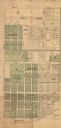
| Date: | 1890 |
|---|---|
| Description: | Map of Milwaukee as remembered by "Dr Enoch Chase, U.B. Smith & Others." Represented are major roads, lowlands, trails, homesteads, and lots. Map depicts t... |
| Date: | 1890 |
|---|---|
| Description: | Map of Merrill Estate property for sale and sold. Map reads: "Merrill Estate property (colored) lots marked X are sold for terms & prices inquire of S.H. C... |

| Date: | 1890 |
|---|---|
| Description: | Shows plat of town, local streets, steam boat landings, and Chippewa River. Public square and Muskoo Island hand-colored. Map reads: "Full Lots are 125x66 ... |
| Date: | 1890 |
|---|---|
| Description: | The map shows roads and railroads, houses, schools, town halls, and other points of interest in parts of Shawano, Oconto, and Brown counties. The lower lef... |

| Date: | 1890 |
|---|---|
| Description: | Map shows St. Croix, Wisconsin and a small portion of Taylor's Falls, Minnesota. Map reads: "The Lands shaded show the Mill & Riparian Reservation & unplat... |

| Date: | 1890 |
|---|---|
| Description: | This map of Superior shows labeled streets, railroads, docks, city wards, and the state line. Relief is shown by hachures. Below the title reads: "Bedford ... |

| Date: | 1890 |
|---|---|
| Description: | This map of Superior shows city wards, bays, docks, some businesses and points of interest. Relief is shown by hachures. The back of the map features a typ... |
If you didn't find the material you searched for, our Library Reference Staff can help.
Call our reference desk at 608-264-6535 or email us at: