 Filter: Categories of Wisconsin Historical Images
Filter: FULL_DATE of 1890
Filter: Subject of cities and towns
Filter: Categories of Wisconsin Historical Images
Filter: FULL_DATE of 1890
Filter: Subject of cities and towns
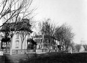
| Date: | 1890 |
|---|---|
| Description: | Several houses at the intersection of Wilson Street and Monona Avenue with the home of Simeon Mills, one of Madison's most prominent citizens, on the corne... |
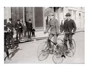
| Date: | 1890 |
|---|---|
| Description: | Two men ride their bicycles past curious on-lookers. |
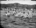
| Date: | 1890 |
|---|---|
| Description: | View across water towards men and boys swimming and splashing in the Mississippi River. Alma is in the background on the far shoreline. |
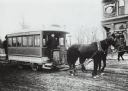
| Date: | 1890 |
|---|---|
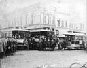
| Description: | Man driving a horse-drawn trolley of the Milwaukee City Railroad Company on the Greenfield Avenue & Third Street line. The corner of a building advertising... |
| Date: | 1890 |
|---|---|
| Description: | A large group of people posing with "Old Oshkosh," a horse-drawn streetcar, and "New Oshkosh," an electric trolley. |

| Date: | 1890 |
|---|---|
| Description: | Portion of the plat map of the north part of Caledonia in Columbia County, including explanations. |

| Date: | 1890 |
|---|---|
| Description: | Plat map of the south part of Caledonia in Columbia County. |
| Date: | 1890 |
|---|---|
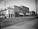
| Description: | Corner of Main and First Street. The first two buildings on the southwest corner are Abraham Meinhold's dry goods and LeClair's hardware store. Next is A.F... |

| Date: | 1890 |
|---|---|
| Description: | City Hall at the intersection of Mifflin Street and Wisconsin Avenue and the Fuller Opera House on Mifflin Street. Snow on the ground. Both buildings were... |

| Date: | 1890 |
|---|---|
| Description: | Bird's-eye view of Superior, Wisconsin. |

| Date: | 1890 |
|---|---|
| Description: | Bird's-eye map of West Superior and Superior, with insets of Wright Farm and First Building in Superior. |

| Date: | 1890 |
|---|---|
| Description: | Colored bird's-eye map of Oconomowoc and the Lake Region, Waukesha County. Looking North from Government Hill. Location key below image identifies 24 Hotel... |
| Date: | 1890 |
|---|---|
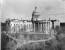
| Description: | The expanded third Wisconsin State Capitol photographed at a time of the year when the trees in the park did not obstruct the view. As a result, the curvil... |
| Date: | 1890 |
|---|---|
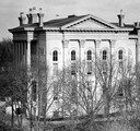
| Description: | Detail of the photograph of the Third Capitol showing the North Wing addition completed in 1883. Designed by D.R. Jones, the North and South additions were... |
| Date: | 1890 |
|---|---|
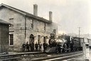
| Description: | Chicago, Milwaukee and St. Paul Railroad locomotive #280 at the Mineral Point depot. A group of people stand on the platform. The depot was built in 1857, ... |
| Date: | 1890 |
|---|---|
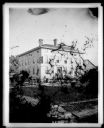
| Description: | The Flom Hotel or American House, located at 323 East Main Street at the corner of South Hancock Street, existed from 1865 to 1925. Attached to the buildin... |
| Date: | 1890 |
|---|---|
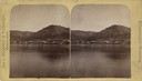
| Description: | Stereograph of Alma from the Mississippi River. Text on front reads: "Wisconsin Scenery". |
| Date: | 1890 |
|---|---|
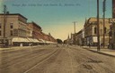
| Description: | View down College Avenue. Caption reads: "College Ave. looking East from Oneida St., Appleton, Wis." |
| Date: | 1890 |
|---|---|
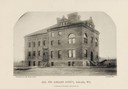
| Description: | Text on front reads: "Jail For Ashland County, Ashland, Wis." and "Conover & Porter, Architects." |
If you didn't find the material you searched for, our Library Reference Staff can help.
Call our reference desk at 608-264-6535 or email us at:
