 Filter: Categories of Wisconsin Historical Images
Filter: FULL_DATE of 1891
Filter: Community of Milwaukee
Filter: Subject of water
Filter: Categories of Wisconsin Historical Images
Filter: FULL_DATE of 1891
Filter: Community of Milwaukee
Filter: Subject of water

| Date: | 1891 |
|---|---|
| Description: | A hand-colored map of Milwaukee County, Wisconsin that shows the township and range system, sections, towns, roads, railroads and rail stations, cities and... |

| Date: | 1891 |
|---|---|
| Description: | This maps has an index of depots, hotels, prominent institutions and buildings, churches, and places of amusement. The map was removed from an unidentified... |

| Date: | 1891 |
|---|---|
| Description: | This map shows railroads, street railways, roads, wards, block numbers, parks, and one mile concentric circles indicating distance from Post Office. Also i... |
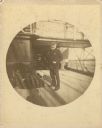
| Date: | 1891 |
|---|---|
| Description: | Frederick Layton standing on deck smoking a cigar while at sea in a Kodak #2 camera portrait by T.W. Ingersoll from St. Paul, Minnesota. The photographer's... |
If you didn't find the material you searched for, our Library Reference Staff can help.
Call our reference desk at 608-264-6535 or email us at: