Filter: Categories of Wisconsin Historical Images
Filter: FULL_DATE of 1900
Filter: County of Ashland
Filter: Categories of Wisconsin Historical Images
Filter: FULL_DATE of 1900
Filter: County of Ashland
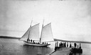
| Date: | 1900 |
|---|---|
| Description: | Sailboat Lizzie W. at the Mission Dock. Captain Daniel Russell Angus, in the white sleeves, is at the tiller. The boat was named after Elizabeth Woo... |
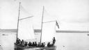
| Date: | 1900 |
|---|---|
| Description: | Group of people on sailboat "Alpha" at dock on Madeline Island. Captain Daniel Angus is at the tiller. |
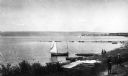
| Date: | 1900 |
|---|---|
| Description: | Elevated view of La Pointe and the shoreline from the Old Mission dock. Two boys and two men stand along the shoreline. The white building with the dark ro... |

| Date: | 1900 |
|---|---|
| Description: | View of La Pointe, Madeline Island, taken from the Mission Inn. |

| Date: | 1900 |
|---|---|
| Description: | The house of Captain Angus on the shore of Lake Superior in La Pointe on Madeline Island sometime around 1900. The Angus family came to Madeline Island in ... |
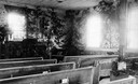
| Date: | 1900 |
|---|---|
| Description: | Interior of the Congregational Church, a.k.a. Old Mission Church. The interior walls are covered with cedar trees. |

| Date: | 1900 |
|---|---|
| Description: | Front view of the four story high school with a tower above the the entrance. Caption reads: "High School, Ashland, Wis." |

| Date: | 1900 |
|---|---|
| Description: | Elevated view of the Masonic Temple with bicycles in front of the entrance. It was built in 1895 of brick and brownstone in the Richardson Romanesque style... |
| Date: | 1900 |
|---|---|
| Description: | Railway passenger depot in Ashland (?), Wisconsin. |

| Date: | 1900 |
|---|---|
| Description: | Wisconsin Central train passing over the White River bridge. The first railroad car is imprinted with "U.S. Mail." |

| Date: | 1900 |
|---|---|
| Description: | View from the top of the Wisconsin Central Railroad White River bridge. |

| Date: | 1900 |
|---|---|
| Description: | This chart of the northern Apostle Islands and Lake Superior shoreline shows relief by contours and spot heights and depths by contours, gradient tints and... |

| Date: | 1900 |
|---|---|
| Description: | This map is shows land in white and water in blue and is indexed for parks, points of interest, schools, churches, and recreational areas. The map shows lo... |

| Date: | 1900 |
|---|---|
| Description: | This map is pencil and ink on tracing cloth and shows local streets, railroads, harbor line, and part of Chequamegon Bay. |
If you didn't find the material you searched for, our Library Reference Staff can help.
Call our reference desk at 608-264-6535 or email us at: